Backtracking the Oregon Trail #7

Day Four ~ Chimney Rock

508.chimney rockHer left boot was getting a hole in it, letting the gritty dust in to nestle between sole and foot and bite in worse than the grit outside the sole. . . . Step after step . . . past natural wonders . . . Chimney Rock . . . Scotts Bluff. . . . She couldn’t get her breath. She was three months pregnant.
A Place of Her Own: The Legacy of Oregon Pioneer Martha Poindexter Maupin, Janet Fisher. (Guilford, CT, Helena, MT: TwoDot/Globe Pequot Press, 2014), p. 116.

Wednesday, June 5. The weather to-day was quite hot and oppressive. We had to cross a long stretch without water. The road we took led us close to the base of Chimney Rock, where we stopped for some time to satisfy our curiosity. The base is shaped like a large cone, from the top of which rises a tall tower or chimney, resembling the chimney of a manufacturing establishment. . . . It is composed of marl and soft sandstone, which is easily worn away. Mr. Frink carved our names upon the chimney, where are hundreds of others.
—The diary of Margaret A. Frink, in Covered Wagon Women: Diaries and Letters from the Western Trails, 1840-1890. Vol. 2, 1850, Kenneth L. Holmes, ed. (Glendale, CA: The Arthur H. Clark Co., 1990), p. 95.

Came opposite Chimney Rock which has been sight since yesterday. It has been seen 30 miles off on a clear day. Three of us went to it. I was struck with amazement at the grandeur of the scene.
—The diary of Lucena Parsons, in Covered Wagon Women: Diaries and Letters from the Western Trails, 1840-1890. Vol. 2, 1850, Kenneth L. Holmes, ed. (Glendale, CA: The Arthur H. Clark Co., 1990), p. 253.

June 14th Traveled twenty four miles:. We have seen very romantic scenery all day; The Chimney rock has been in full view all day:; It is represented as being three hundred feet high but from the road we are traveling it does not appear to be more than one hundred feet.;. Palmer in speaking of this rock very truly says that it has the unpoetical appearance of a hay stack with a pole extending far above its top
—The diary of Abigail Jane Scott, in Covered Wagon Women: Diaries and Letters from the Western Trails, 1840-1890. Vol. 5, 1852, The Oregon Trail, Kenneth L. Holmes and David C. Duniway, eds. (Glendale, CA: The Arthur H. Clark Co., 1986), pp. 65-66.

To day we come to the river opposite Chimney Rock which has been visible most of the way for the last 35 miles It is said to be 3 miles from the opposite side of the river but on these level prairies we cannot judge much of distances by the eye It does not appear more than half a mile It consists of a large square column of clay and sand mixed together with a base of conical form apperantly composed of sand, round base cone. and appears as if the column had been set up and the sand heaped around it to sustain it It is said to be 500 feet high but doubt it some
—The diary of Cecelia Adams & Parthenia Blank, in Covered Wagon Women: Diaries and Letters from the Western Trails, 1840-1890. Vol. 5, 1852, The Oregon Trail, Kenneth L. Holmes and David C. Duniway, eds. (Glendale, CA: The Arthur H. Clark Co., 1986), p. 271.

At night we came to Chimney rock which had been visible to us for 15 miles. . . . We camped near the river about two miles from the rock. After tea uncles, Mr Long, Julia Martha & I went to see it by moonlight The sight was awfully sublime The sides of the base on which the pillar rests are so steep that it was with the utmost difficulty we could climb up it at all. We however succeeded in climbing up some distance. We found it covered with names We got back to the camp about 10 O’clock
—The diary of Celinda Hines, in Covered Wagon Women: Diaries and Letters from the Western Trails, 1840-1890. Vol. 6, 1853-1854, Kenneth L. Holmes, ed. (Glendale, CA: The Arthur H. Clark Co., 1986), pp. 92-93.

502.painted wagon & oxen scotts bluff
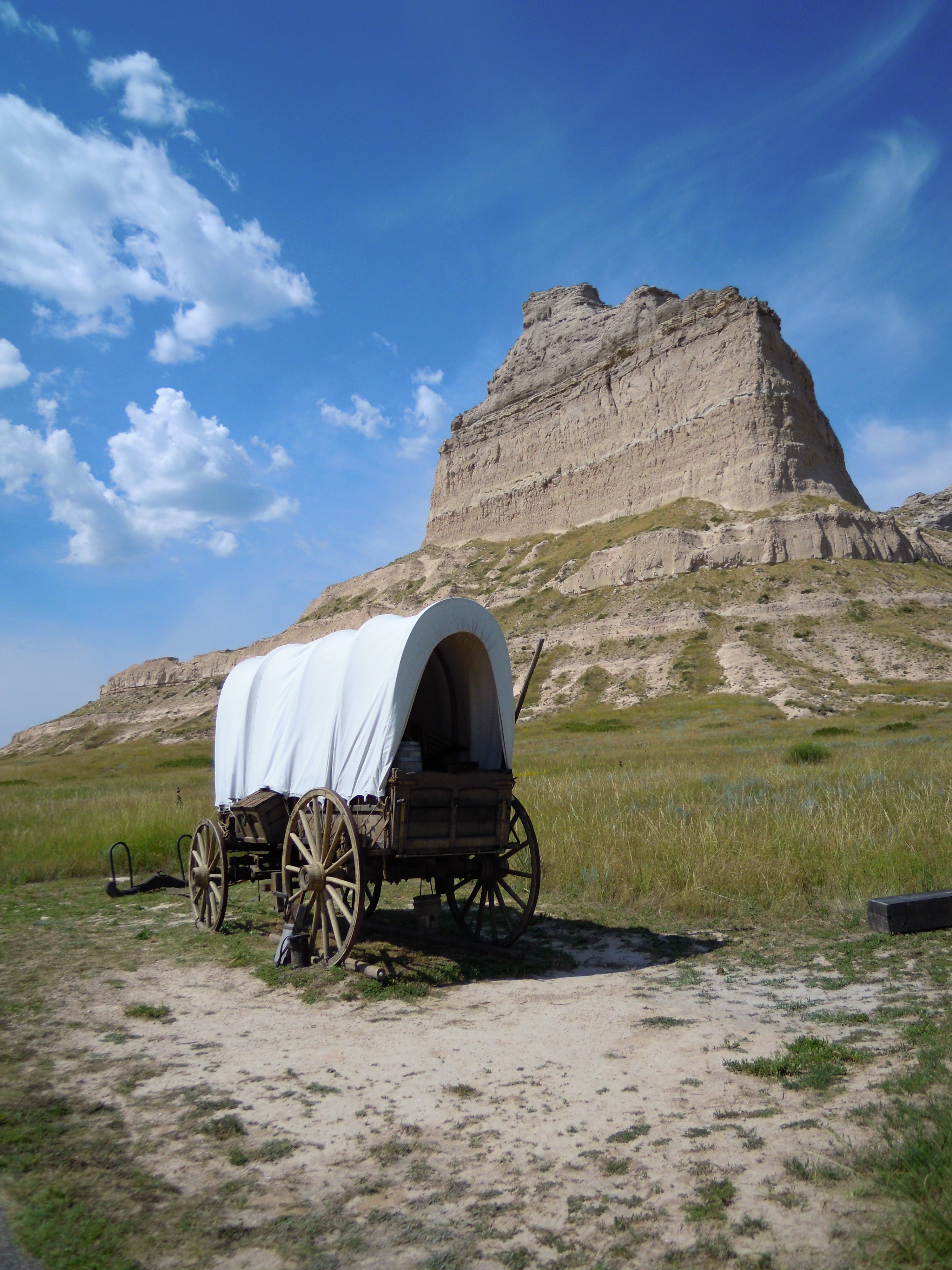
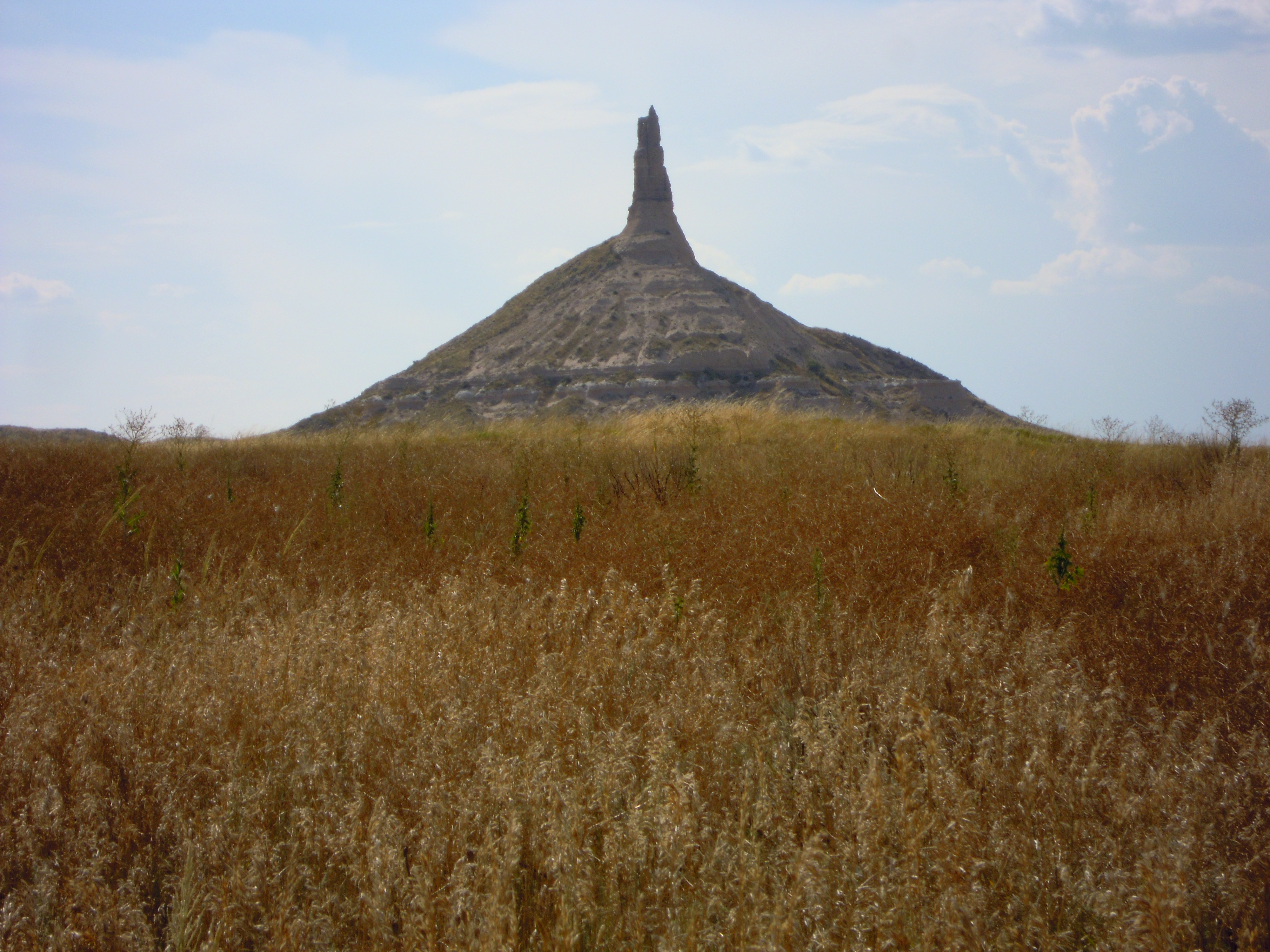
Downriver from Scotts Bluff my family and I finally came upon another of the famous landmarks along the Oregon Trail, Chimney Rock. Traveling eastward, we didn’t see it right away. But perhaps even more than Scotts Bluff, this one cannot be mistaken once seen. Many a pioneer commented on this remarkable feature that points a jagged finger to the rich blue skies.

The pinnacle rose before us, one of the more amazing sights on our journey from Oregon to Kansas City, as we retraced the footsteps of our pioneer ancestors who took this trail westward. My daughter Christiane and I had seen it years ago when our family took a camping trailer over this route. And having traveled the trail again in my mind as I wrote Martha’s story, A Place of Her Own, I thrilled to see it firsthand once more and show my granddaughter as well.

By the time we reached the visitor center for this geological marvel, the thermometer was inching up to 100. And at this site we didn’t see a speck of shade. We dismissed any notion of trekking to the monument’s edge, but I hurried into the visitor center while my daughter and granddaughter stayed with the dog in the air-conditioned car, the motor running. I had previously sent a copy of my book to be reviewed for their gift shop and stopped in to introduce myself.

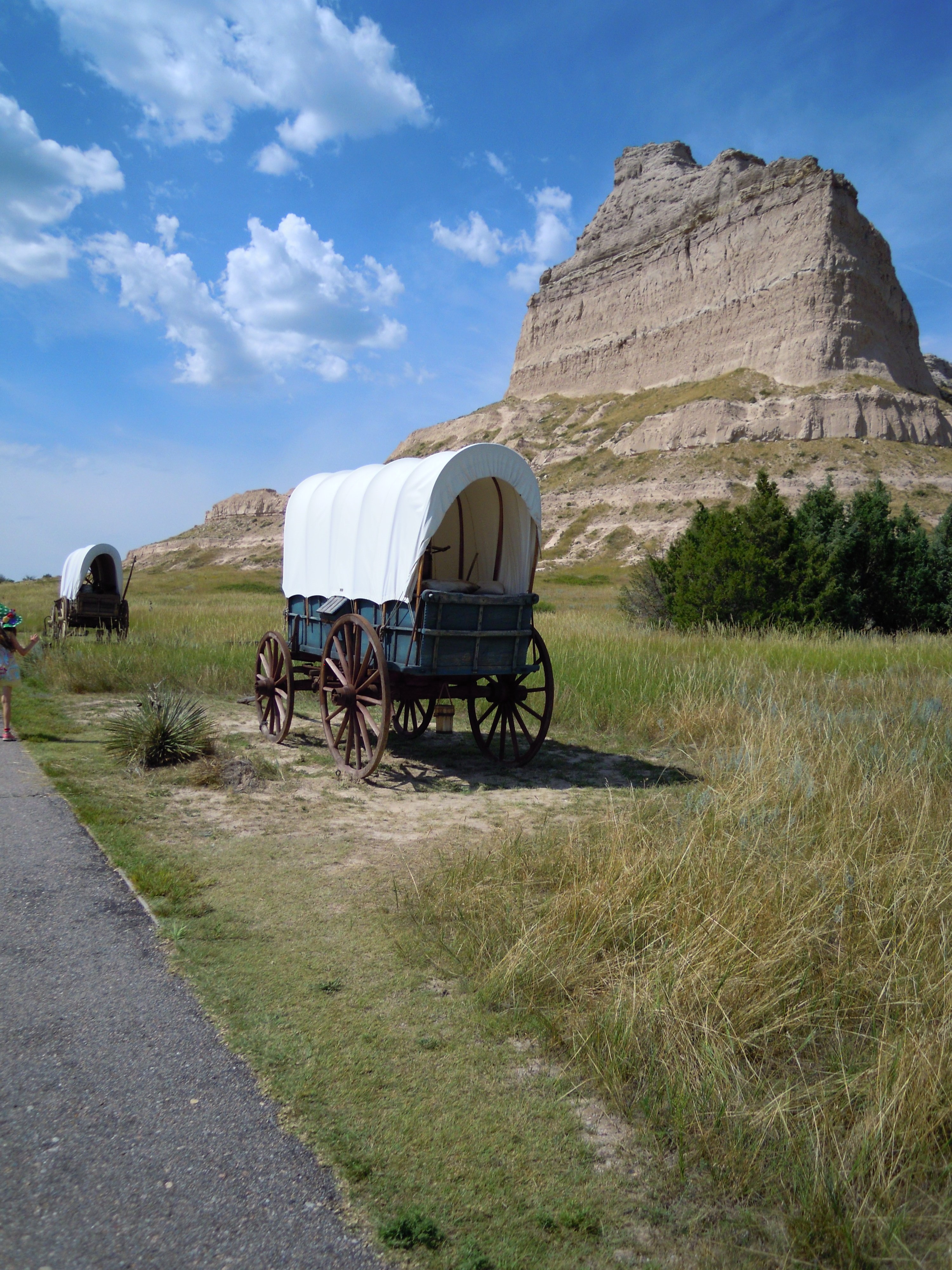
Thinking about our pioneers ancestors, I could only imagine how miserable it would have been for these people and their animals to trudge across the barren land here on days such as this. The photo above of a painted wagon and oxen from the Scotts Bluff site helps bring the image to life.

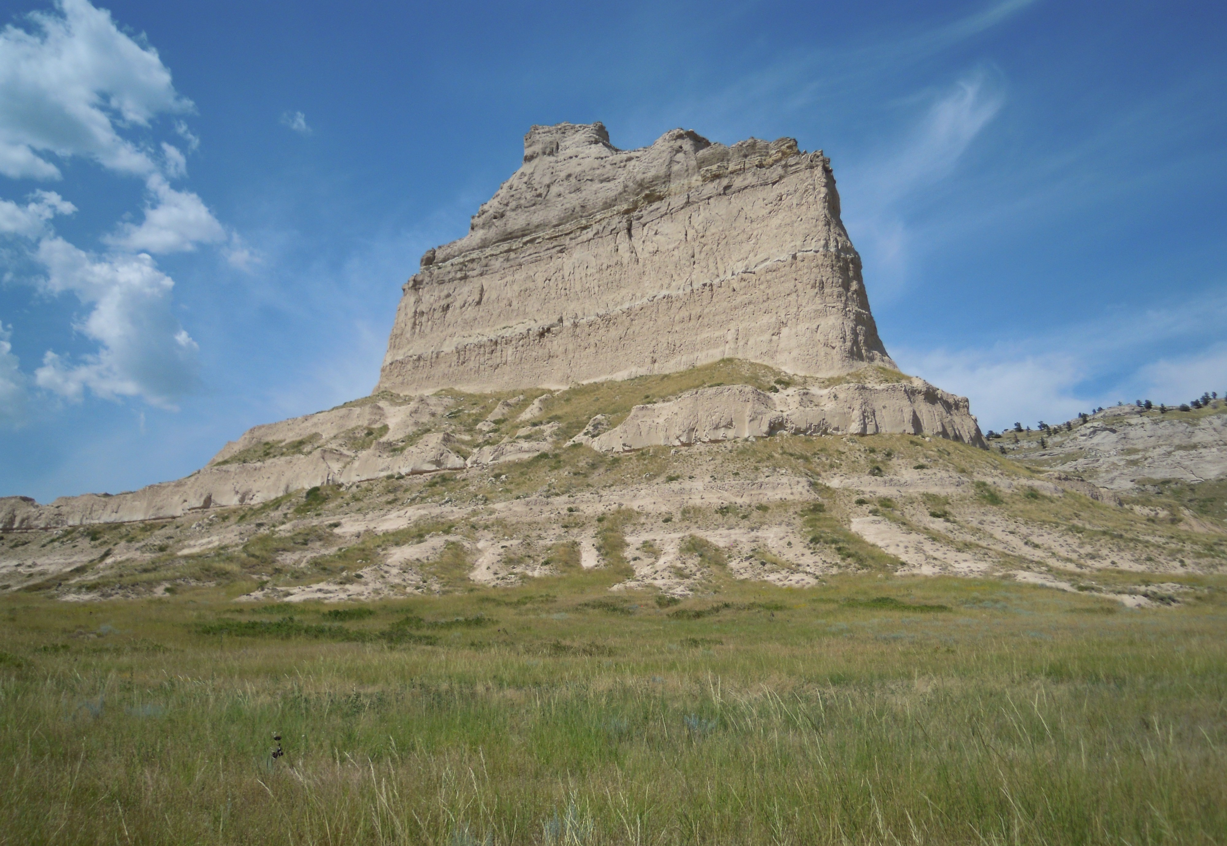
As with Scotts Bluff, the sediments on the unusual Chimney Rock landmark show the many layers set down by nature over time. Travelers along the Oregon Trail must have wondered how these imposing features happened to be here. The formations appear to hold the strength of the ages, but they’re gradually disintegrating, much as they’ve been doing for thousands of years.

Scientists say it all started with a major geological uplift along North America’s west coast 70 million years ago. A huge inland sea once covered this central part of North America, but that land rise on the coast created the Rocky Mountains, displacing the inland sea. Water on the east side began to wash into the Mississippi River Basin. Wind and water carried huge amounts of sediment from the Rockies and deposited it here in layers of sand and silt, the accumulated weight compressing the deposits into sandstone and siltstone. Periodic volcanic activity added layers of ash.

Then about 10 million years ago the uplift increased, and streams moved faster, carving deep into the deposits. Here and there, denser stone held firm, where hard capstones of limestone at the top held down the layers so they still show like a layer cake of varied flavors.

509.chimney rock & sunflowersWe saw lots of wild sunflowers along the way. They looked pretty next to these unidentified white flowers near Chimney Rock (directly above). We saw many bunnies and a magpie or two, but none of the prairie rattlesnakes that signs warned us about.

Life forms no longer seen in this area walked these lands 30 million years ago. Their fossils have been preserved in the sand and silt layers—animals like rhinos, camels, giant hogs, and a few stranger creatures, as well as huge turtles.

Humans began appearing around 10,000 years ago, or possibly earlier. People developed agriculture along the North Platte River, then abandoned the area around 1400 AD, probably due to drought. Later, eastern tribes were pressed into the area by European settlement. When the Spanish reintroduced the horse to this continent in the 16th century, that animal changed the lives of the tribes then living on the plains, providing mobility and prowess in battle. These were the people American emigrants met on their way west over the Oregon Trail.

Scotts Bluff National Monument: Landmark on the Overland Trails, A History and Guide, Dean Knudsen, Historian, National Park Service, pp. 2-7.

NEXT: The North Platte and Ash Hollow

COMMENT


Portraits of a Century Farm ~ Haunting Gems

Robin Loznak captured this photo on a dewy October morning on the Martha A. Maupin Century Farm in Oregon, as an industrious spider seeks breakfast in her dew-jeweled web before a backdrop of leaves in glorious fall color. She put me in mind of Halloween on this upcoming edge between summer and winter when we recall in one way or another the ancient celebration of the edge between life and death.

web-Fall-Spider01

Haunting Gems

Deadly beauty spins a tale in pearls of light
As days rush by to Halloween.
Death to life, and life to death.
Strands gleam against a sheen of gold,
Leaves soon to scatter off skeletal limbs.

Chill runs in the air and down the spine
With pumpkins glaring in the dark
And children braving hideous things.
Blood, gore, goblins, cackling witches,
And gauzy webs a-streaming.

Look at death and laugh.
Who can be the scariest?
Look at the edge and shiver.
Life to death, and death to life,
Glimmering in our frightful dreams.

Deadly beauty spins a tale in pearls of light.
On this fine autumn day
As life around it ebbs,
One creepy, crawly, skittery, artful, exquisite creature
Hangs waiting for a meal.

COMMENT

Backtracking the Oregon Trail #6

Day Four ~ Scotts Bluff

501.one wagon scotts bluffShe walked past natural wonders . . . Chimney Rock . . . Scotts Bluff . . . the Devil’s Gate. The oppressive heat sucked her energy. Dust filled her nose and eyes, even her ears. Sounds dimmed—the creaking wheels. Cattle bawling. Thudding hoofbeats. Ropes squeaking. . . .
A Place of Her Own: The Legacy of Oregon Pioneer Martha Poindexter Maupin, Janet Fisher. (Guilford, CT, Helena, MT: TwoDot/Globe Pequot Press, 2014), p. 116.

June 27 thursday we started on and traveled ten miles and stoped to noon in sight of scots bluffs whare their was plenty of grass for the catle we traveled twenty miles and encamped in sight of scots bluffs right on the plat river and I washed some that evening we had plenty of wolfs to visit us that night
—The diary of Sarah Davis, in Covered Wagon Women: Diaries and Letters from the Western Trails, 1840-1890. Vol. 2, 1850, Kenneth L. Holmes, ed. (Glendale, CA: The Arthur H. Clark Co., 1990), p. 180.

July 28. We currelled last night opposite the most splendid scenery we have met with on our travels. They are sand hills intermixt with rock or a hard substance resembling rock that rise & tower over the other like splendid mansions with numerous chimneys rising to a great hight. They are called Scotts Bluffs . . .
—The diary of Lucena Parsons, in Covered Wagon Women: Diaries and Letters from the Western Trails, 1840-1890. Vol. 2, 1850, Kenneth L. Holmes, ed. (Glendale, CA: The Arthur H. Clark Co., 1990), p. 253.

About noon we stopped nearly opposite the “Scott bluffs” sometimes called capital hills These hills have a truly grand romantic appearance calculated to fill the mind with indescribeble amazement approaching almost to sublimity. There are numerous cedars growing uppon them, which gives them a still more grand appearance.
—The diary of Abigail Jane Scott (entry by Margaret Ann or Maggie because Abigail has cholera), in Covered Wagon Women: Diaries and Letters from the Western Trails, 1840-1890. Vol. 5, 1852, The Oregon Trail, Kenneth L. Holmes and David C. Duniway, eds. (Glendale, CA: The Arthur H. Clark Co., 1986), p. 66.

All day the scenery was most enchanting intirely surpassing in loveliness & originality any thing I had ever beheld. Bluffs the most picuresque and resembling to the life some old castle of ancient times. About noon we came to Scotts Bluff which much resembles an old fortification.
—The diary of Celinda Hines, in Covered Wagon Women: Diaries and Letters from the Western Trails, 1840-1890. Vol. 6, 1853-1854, Kenneth L. Holmes, ed. (Glendale, CA: The Arthur H. Clark Co., 1986), p. 93.

506.scotts bluff visitor ctrDay four brought our backtracking trip right back to the Oregon Trail along famous landmarks for the emigrants on their way west. The emigrants would gauge their progress by the number of days it took them to reach these notable places. On our journey eastward to my daughter Christiane’s new job in Kansas City near the trail’s beginning, we planned to stop at several of these locations, where visitor centers provide information.

The towering landmark of Scotts Bluff rises like a beacon in the vast high plains of what is now western Nebraska, layers of multicolored sediment marking the deposits placed there by great upheavals of nature over time, water and wind whisking away the edges to let the monument stand high above the surrounding plain and expose its turbulent history.

We watched for the famous bluff out the car window, as those emigrants traveling the Oregon Trail must have watched. Several lesser bluffs rose around us, scattered over the flat. Was that it? No, not prominent enough. Then a sign marked the way, and when we came closer there could be no doubt. Nothing in the area matched the monumental geological feature. The emigrants with their slow travel might have seen it for days, growing slowly larger before them. This was one of the great mileposts. They knew from the guidebooks they carried that reaching this landmark along the North Platte River meant one-third of their trip lay behind them. And what a marvel, seeing it up close!

Now a visitor center nestles against the sheer height of Eagle Rock. Between that and Sentinel Rock, three covered wagons appear to roll through a wide gap, following the historic trail.

We stepped out of our air-conditioned car, and the heat struck. The hot weather was back. Not quite 100, but in the high 90s—in the shade. And precious little shade beyond the perimeter of the visitor center, where nice trees provide refreshing cover.

After checking in at the center—and giving them one of my books—we left the trees and started our own trek along the short stretch of the Oregon Trail within the park boundaries.

500.two wagons scotts bluffMy grand-daughter Calliope walks ahead at the far left edge of the scene.

There’s a bit of shade alongside the wagon, but when those wagons rolled, back in the day, the dust must have boiled up around them. A person could have shade with dust or blistering sun without. What a choice!

We reluctantly had to forgo the walk we had intended to make up to the wagon wheel ruts farther up the trail, hoping for another visit sometime on a cooler day or perhaps during the morning or evening hours. Unfortunately our schedule didn’t allow us to wait.

A haunting story tells how the bluff got its name, a story with moving parts that shift like sands along the Platte, depending on who does the telling. But apparently an employee of the American Fur Company named Hiram Scott had served as a clerk with the caravan that brought supplies to trappers at the 1828 Rocky Mountain Rendezvous. On their way home, laden with furs from the mountains, Scott became too ill to ride. So the leader of the caravan put him in a bullhide boat and assigned two men to accompany him more slowly downriver the 60 miles or so to this bluff, where the rest of the men would wait for them.

Somehow the boat overturned, and the three men lost most of their supplies, including food and weapons. Unable to hunt or protect themselves, the two with Scott told him they would hurry on ahead to catch up with their company and return for him. Or they said they would go out and find food and natural medicines to take back to him, according to another version of the tale.

However, when the two reached the bluff they found that the company had gone on ahead, so they decided to abandon poor Scott and push forward as fast as they could, finally catching up with the others in two or three days.

A couple of the women diarists offer a kinder version. Abigail Jane Scott says the sick man requested that his companions abandon him. Celinda Hines brings in a robbery by the Indians, who supposedly wounded Mr. Scott. She says they all knew he wouldn’t last much longer, so Mr. Scott begged his companions to leave him, which they did.

504.scotts bluffAnd so the sand of story shifts. In any case, the next spring when the caravan rolled by the bluff again, men found a grinning skeleton they readily identified as Scott. With remarkable tenacity he had made his way those 60 miles alone, finally to die at the foot of this monument which would thereafter carry his name. The story in its variations was told around many a campfire as others pushed west, passing this magnificent marker.

Scotts Bluff National Monument: Landmark on the Overland Trails, A History and Guide, Dean Knudsen, Historian, National Park Service, pp. 10-13.

—The diary of Abigail Jane Scott, in Covered Wagon Women: Diaries and Letters from the Western Trails, 1840-1890. Vol. 5, 1852, The Oregon Trail, Kenneth L. Holmes and David C. Duniway, eds. (Glendale, CA: The Arthur H. Clark Co., 1986), p. 66.

—The diary of Celinda Hines, in Covered Wagon Women: Diaries and Letters from the Western Trails, 1840-1890. Vol. 6, 1853-1854, Kenneth L. Holmes, ed. (Glendale, CA: The Arthur H. Clark Co., 1986), p. 93.

NEXT: Chimney Rock

COMMENT

Backtracking the Oregon Trail #5

Day Three ~ The High Plains

463.wagons high plainsWind whistled across the high desert. The sun shone warm on her back, not a cloud in the sky. Nights had been cold, though, everything white with frost in the mornings. The acrid smell of sage clutched her nose. She’d been tasting it for days. The scrubby plants dotted the landscape, along with other low, tangled brush, a spare coat of dry grass like a mangy dog’s hair.
A Place of Her Own: The Legacy of Oregon Pioneer Martha Poindexter Maupin, Janet Fisher. (Guilford, CT, Helena, MT: TwoDot/Globe Pequot Press, 2014), p. 116.

Wedns Aug 4 Traveled 8 miles. Came to Soda Springs. laid by the rest of the day. Here is quite a curiosity. The water boils right up out of high rocks in some places and it boils out of the level ground quite . . . high. The water is not so strong but what a person can drink it very well.
—The diary of Martha S. Read, in Covered Wagon Women: Diaries and Letters from the Western Trails, 1840-1890. Vol. 5, 1852, The Oregon Trail, Kenneth L. Holmes and David C. Duniway, eds. (Glendale, CA: The Arthur H. Clark Co., 1986), p. 236.

July 6th We traveled 18 miles through the Pass;; The ascent and descent is very gradual it being impossible to exactly determine where the culminating point is. . . . The next stream we passed was a small one called Pacific Creek The water here runs West while every other stream we have passed runs either (East) or South
—The diary of Abigail Jane Scott, in Covered Wagon Women: Diaries and Letters from the Western Trails, 1840-1890. Vol. 5, 1852, The Oregon Trail, Kenneth L. Holmes and David C. Duniway, eds. (Glendale, CA: The Arthur H. Clark Co., 1986), p. 82.

August 1st Sunday To day we left the waters that flow into the Atlantic and proceed to those of the Pacific We let our cattle feed till about noon and then started on, for the South pass 10 miles distant – It ill comports with the ideas we had formed of a pass through the rocky Mountains, being merely a vast level sandy plain sloping a little each way from the summit and a few hills for we could not call them mountains on each side. Some few snowy peaks in the distance, and this is the South pass through the Rocky mountains
—The diary of Cecelia Adams & Parthenia Blank, in Covered Wagon Women: Diaries and Letters from the Western Trails, 1840-1890. Vol. 5, 1852, The Oregon Trail, Kenneth L. Holmes and David C. Duniway, eds. (Glendale, CA: The Arthur H. Clark Co., 1986), p. 278.

493.mountains to crossAs we continued our journey to Kansas City, retracing the footsteps of our ancestors over the Oregon Trail, I kept picturing Martha, subject of my new book A Place of Her Own, walking this rugged track in 1850 with her husband Garrett Maupin, all their worldly goods packed in an ox-drawn covered wagon. My great-great-grandparents. What hardy souls they were.

Leaving Fort Hall, my daughter, granddaughter, and I struck out eastward toward Soda Springs, where pioneers marveled at natural fountains of soda they could drink like a soda back home. My granddaughter Calliope was determined to buy a soda in the town of Soda Springs. Checking the label she found that the soda came right out of—well, Mexico. But she insisted it was delicious anyway.

Weather had turned cooler today, thankfully, perhaps because we’d moved into higher elevations, or the overall weather patterns had changed. We could enjoy getting out and walking around.

We soon crossed the modern border into Wyoming somewhere near the Oregon Trail with another looming ridge in the near distance. The range extended on either side of the road and looked too wide to go around. We would have to go over.

494.continuing rangeI couldn’t help thinking how the hearts of those pioneer travelers must have sunk, seeing ridges like this ahead of them and wondering what manner of mountains they were coming into now. As we followed the highway into this ridge, the road rose before us and we could hear the subtle change in the laden car’s engine. Imagine taking this step by step, one foot in front of the other, the oxen tugging that laden wagon up a slope with no smooth highway, only a rutted track.

Of course, they were coming the other way. They faced this mountain from the other side. Our uphill slope was their downhill grade. But downhill isn’t so easy either. While there isn’t the tug of hauling weight upward, a decline can be treacherous. A heavy wagon pushing down on you. Rocks in the path ready to trip a person or flip a wagon. Truckers today understand the danger of a runaway vehicle on a steep descent. A runaway wagon could happen too. Mountains, beautiful as they are, must have always evoked dread.

We left the Oregon Trail somewhere in western Wyoming. The main highways in Wyoming veer from that track, and we had limited time. We had a long drive ahead before we reached our day’s destination, and my daughter had meetings scheduled the morning after our scheduled arrival in the Kansas City area at the end of Day 5. We needed to take the fast route across Wyoming. And I do mean fast. Much of Interstate 80 is posted at 80 mph. That does make the miles slip by.

Again I thought of the pioneers who faced other kinds of time constraints. They had to get across the last mountain before winter snows came. They may have had some flexibility of days, but they didn’t dare delay too long.

Years ago when my kids were young our family had taken the more northerly zigzagged route across Wyoming on a road trip with a travel trailer—our version of a covered wagon—and we did our best to follow the Oregon Trail all the way. I well remember the surprising topography of South Pass where the trail crossed the Continental Divide which separates the waters that flow to the Pacific from waters that flow ultimately to the Atlantic. It doesn’t appear mountainous at all. It’s just a slight rise in ground in the midst of a dry plain, dotted with sagebrush and other scrub. Such luck for all who passed that way in the early days that they found this easy crossing through the otherwise craggy mountain range of the Rockies.

495.sediment on rocksOur crossing of the Continental Divide on Interstate 80 wasn’t much more noticeable. We saw a lot of country like the above, wide flat stretches of sagebrush and dry tufts of grass with multicolored bluffs rising here and there. Barren but beautiful. I liked the soft reds in the bluff above, which I shot while the car surged forward.

497.colored rimrockAnd this formation near Green River, Wyoming, was interesting with its strawberry tint in layer-cake slices. I think I was beginning to get hungry.

After two nights of drive-through fast-food dinners gulped down in the air-conditioned car because it was too hot to leave the dog, we decided this evening we would have a sit-down dinner in a restaurant. The weather had remained pleasant all day. The dinner couldn’t be anything fancy. We were still far from our motel in Laramie and needed something quick. But quick wasn’t in the cards that evening. Food took a long time to reach our table. My daughter, who did the driving, bolted hers down. My granddaughter and I got to-go boxes. And off we went again. So much for a relaxing dinner.

Dark fell much too fast, and it was 10 o’clock by the time we rolled in. I thought about Martha and other emigrants who made those night runs across the desert when the weather became too unmercifully hot to travel in the day. Ours was just a little miscalculation of the time this portion of the drive would take, a late start due to loss of sleep from parties next door, and slow dinner service.

One thing. We slept well this night.

[The wagon photo at the top was taken at the National Historic Oregon Trail Interpretive Center at Baker, Oregon.]

NEXT: Scott’s Bluff, famous landmark of the trail

COMMENT

Both Sides of the Mountain

683.sisters at sistersOctober started in a rush of activity with three book events in a row for me on both sides of the Cascade Mountains, the range that neatly divides Oregon into two very different landscapes. On October 2nd I enjoyed a lively discussion with an enthusiastic group at Amanda Bird’s “Lunch With An Author” at her Book Nest store in Springfield on the west side. And on the 3rd and 4th I enjoyed two nights with enthusiastic readers in the Paulina Springs bookstores, one in Sisters and one in Redmond on the east side. The above photo shows the Three Sisters which rise along that central range and overlook the town of Sisters with their proud beauty.

When I left I-5 for Highway 126 on my way to the Book Nest in Springfield I realized I could have just kept going east after lunch and would have ended up at my next location, but I opted to return home for another night in my own bed.

The Book NestAmanda Bird hosts a delightful venue of author lunches at her Book Nest, shown at left. Located in the Indulge! Antiques complex in Springfield, she takes advantage of the restaurant there to serve the lunches. We all sat around a long table, ate delicious food, and talked about my book. She has many regulars who attend these events, and they welcomed me with many thoughtful questions and comments of interest. My thanks to Amanda for the invitation. A fun time!

The next morning I headed eastward into the mountains, taking Highway 58 over the Willamette Pass and up Highway 97 through Bend to Redmond, where I stayed overnight.

659.room view redmondAnd what do you know but I had another room with a view. Those Three Sisters, even in more distant Redmond, still dominate the skyline. Some trees had already lost leaves, but snow remains sparse on the peaks.

With a quick change of clothes, I drove over to Sisters for the first night’s event with Paulina Springs Books.

657.hood avenueI found the store on Hood Avenue, which is a charming street of art galleries and other shops with a hint of the Old West in their board and batten structures and high storefront faces. Since the event started at 6:30, I got an early dinner in a courtyard restaurant at the Open Door across the street. The evening air lay softly over me as I sat in the courtyard among tall pines and quivering aspen, listening to haunting strains of music that sent my mind back to Martha’s story of love and loss.

656.sisters bookstoreAt the bookstore I was welcomed by Amanda MacNaughton, who’d invited me for the two events at Paulina Springs Books, and Ruth Ann Sparks, who would introduce me to people who attended.

The store has a strong following with their many regular author events. They provide refreshments and a raffle, and Ruth Ann gave me a lovely introduction. After my reading, we had some excellent book talk. A great evening!

Having most of the next day free, I decided to explore the area. I hadn’t been there in years.

660.cline falls lunchFirst, I wanted to see the nearby sights. I opted to grab a takeout sandwich for lunch and carried it with me to Cline Falls State Park, east of town.

A perfect day for lunch by the riverside.

After lunch I noticed Smith Rock State Park on the map north of town and decided to check that out.

673.smith rock.1Even as I approached the place I realized this was something spectacular. Great spiky rock formations rose from the broad landscape as if set there by mistake.

Volcanic activity had a large part in the overall landscape of Central Oregon, and this accumulation of rock formations resulted from several upheavals about 30 million years ago. Calderas collapsing. Molten rock erupting. Lava flowing. And a river cutting through.

Today it’s a hot spot for rock climbers. And there are many hiking trails. I love a good hike, but took only a short one, given my time limitations. And I’d have preferred my serious hiking boots on the steep gravelly slopes. Fortunately I’d at least thrown in my walking shoes. A fascinating place.

677.smith rock.2680.redmond bookstoreBack in Redmond, I prepared for the next event at Paulina Springs Books’ Redmond store. It’s right downtown on another street of art galleries and restaurants and other shops. Redmond has done a lot with their downtown to give it new life and make it a pleasant walking town.

The bookstore offered refreshments and a raffle here too, but they didn’t expect as many people as at Sisters. We didn’t have quite a full house in Sisters, but a good crowd. Well, in Redmond, the chairs soon filled and Ruth Ann had to scramble to move aside more book stacks and bring out more chairs. For once, Redmond outdid Sisters for numbers. Several had come expecting to hear about Martha’s “place” in Maupin, Oregon, and I had to tell them she never went to Maupin. But the town was named for her husband’s brother Howard, so it was all in the family. They seemed to accept that, and we had another lively Q&A session. Thanks again to Amanda, to Ruth Ann for her friendly introduction, and to Cedar Goslin for rushing out to the car with me for more books when the store ran out–a situation to delight an author. Another outstanding event!

685.mckenzie summit sign688.stark tree in lavaThe next day I set out for a leisurely drive home by way of McKenzie Pass, traveling through open forests of tall Ponderosa pines with their beautiful red jigsaw-puzzle bark and feathery needles, up a winding, narrow highway, to the lava beds on top. Volcanic upheavals sprinkled so much rock.

I could hardly believe the sign that showed tracks where wagons came that way in the 1860s. Right through the lava. The Cascade Mountains offer no easy way across, but this pass presents one of the more demanding routes even today.

Many dead trees scatter across the broad fields of lava. I didn’t find it surprising they were dead, but that many were still standing. They make a stunning impression.


686.lava fields

Beyond the lava beds Mount Washington rises in a jagged point on the left and Mount Jefferson forms a snow-laced cone in the distance on the right.


Turn the other way and you see two of the Three Sisters (below). The South Sister is hiding behind the Middle Sister.

687.sisters from pass

Finally, coming down the twisting route into the thicker woods of the western side of the mountains (below), a spray of sunlight seems to breathe the fire of life into the vine maple.

I take my own deep breath and am content.

689.vine maple mckenzie pass

COMMENT

Backtracking the Oregon Trail #4

Day Three ~ Fort Hall

481.Ft Hll exteriorMartha batted away mosquitoes as she sat in the shade with the girls and several other women and children outside the sturdy structure. Fort Hall. What a relief to find this semblance of civilization so far out in the wilderness. It also meant they’d covered a fair amount of their journey, but when she asked Larry if it would be downhill from here, he wouldn’t answer.
A Place of Her Own: The Legacy of Oregon Pioneer Martha Poindexter Maupin, Janet Fisher. (Guilford, CT, Helena, MT: TwoDot/Globe Pequot Press, 2014), p. 118.

July 23rd We traveled 18 miles;;, twelve and a half miles brought us to fort Hall. . . . This fort is built of sun burnt brick (adobes), It is a rather shabby looking concern, but in case of an attak from without its inmates would be tolerably well protected It has port holes through the walls for the admission of guns,; This fort is now abandond by the government and is occupied by some traders;;
—The diary of Abigail Jane Scott, in Covered Wagon Women: Diaries and Letters from the Western Trails, 1840-1890. Vol. 5, 1852, The Oregon Trail, Kenneth L. Holmes and David C. Duniway, eds. (Glendale, CA: The Arthur H. Clark Co., 1986), p. 94.

[August] 19 Thursday To day came to Fort Hall on snake River and passed it at one in the P.M. It is made of unburnt bricks and is little larger than a good sized barn. It is not now occupied by the soldiers but is used for a trading station. Some 50 or 100 wagons, markd U.S. in large letters stand there rotting. Encamped about 2 miles from the fort on Pannock creek and had very good feed – Made 14m
—The diary of Cecelia Adams & Parthenia Blank, in Covered Wagon Women: Diaries and Letters from the Western Trails, 1840-1890. Vol. 5, 1852, The Oregon Trail, Kenneth L. Holmes and David C. Duniway, eds. (Glendale, CA: The Arthur H. Clark Co., 1986), p. 284.

28th Thursday . . . We almost suffered with dust & want of water Near night we came to the Port Neuf river which we had to ford it is large & deep we had to raise our wagon beds. Ft Hall trading post is near . . . The men from the post came to see us . . .
29 Friday Our road was through sage brush . . . The mosquitoes were very annoying.
—The diary of Celinda Hines, in Covered Wagon Women: Diaries and Letters from the Western Trails, 1840-1890. Vol. 6, 1850, Kenneth L. Holmes, ed. (Glendale, CA: The Arthur H. Clark Co., 1986), p. 106.

474.inside ft hallAnd so continued the journey of my daughter and granddaughter and myself as we retraced the footsteps of our Maupin ancestors who traveled west over the Oregon Trail in 1850. Now we were backtracking the trail, heading east on our way to Kansas City, where my daughter was moving to take a new job.

We got a late start on day three after a rocky night of sleep the night before when our neighbors in the motel made a little too much noise partying. I was reminded of complaints by some emigrants on the Oregon Trail concerned about Indian drums pounding all night, keeping them awake.

To add to our delay, we also had some trouble finding Fort Hall. But once we found it, we took our time to see this fine replica in Pocatello, Idaho.

Fort Hall became another milepost for the weary emigrants trekking across the Oregon Trail. It meant they had come about two-thirds of the way on this incredible journey. Although the fort may have become a little dilapidated, some found comfort in the presence of an actual man-made structure in this wilderness.

The tidy structure today is a replica, built a few miles from the original. The builders did their best to create an authentic reproduction, using plans maintained by the Hudson’s Bay Company. I had a nice chat with the staff people. A man I’d spoken to earlier by phone met me there, and I left them a copy of my book, A Place of Her Own, about my great-great-grandmother Martha Maupin who took that trek west with her husband and their two small daughters.

The original fort came into being somewhat by accident. Nathaniel Wyeth, an American businessman from New England, became interested in the fur trade sometime in the early 1830s. Wyeth visited the annual Rocky Mountain Rendezvous of mountain men, Indians, and traders in 1832. There he negotiated with leaders of the Rocky Mountain Fur Company, one of the American companies that took supplies from St. Louis to the mountains for that annual gathering where they would trade supplies for furs that trappers and Indians had collected during the year. Wyeth offered to bring trade goods to the 1834 rendezvous, hoping to do a good business.

429.palisades like wyeth's - cropHowever, the Rocky Mountain Fur Company had financial difficulties and didn’t accept Wyeth’s goods. With $3,000 worth of supplies on hand and no buyer, Wyeth decided to build a trading post, which he named Fort Hall.

He constructed a wooden fort with palisade walls like those shown here (on the right), put up a handmade American flag, and left a man to run the post.

The British Hudson’s Bay Company didn’t look so kindly upon this American intrusion in the territory they wanted to claim for themselves. They built another fort a few miles downriver, Fort Boise, and soon put Wyeth out of business. By 1837 Wyeth gave up and sold his fort to the HBC at a loss.

The HBC covered the palisade walls with adobe. The place was still in the hands of the HBC in 1850 when Martha saw it, but the HBC abandoned it in 1855 or 1856, according to the Fort Hall Replica website (link below). Butruille (cited below) indicates the U.S. took it over in 1855. However, a couple of diarists (above), writing in 1852, suggest a former U.S. military presence at the time they passed through. Writers of history often disagree, I’ve found, and the diarists may not have been aware of the fort’s history.

In any case, the original was eventually abandoned as it began to crumble, and bits and pieces were carted off for other uses. But residents of the area later decided to replicate it. Since they could not build on the original site they put the structure on a lovely rise in ground at Ross Park in Pocatello.

477.blacksmith shop ft hallChristiane and Calliope and I traipsed through the interior, where many rooms have been set up like the originals. In the above photo of the blacksmith shop you can see the large bellows for raising the fire’s heat, an anvil, and other equipment. A blacksmith shop would have been a welcome convenience for the travelers whose wagons were often in need of considerable repair after so many jolting miles.

We took our time exploring each room and imagining what it must have been like to see Fort Hall in its original state, its adobe walls looming boldly in this land of wild rivers and mountains and plains of sagebrush. It must have looked a little out of place. And yet for people longing for any suggestion of civilization, the sight could well have provided a moment’s sigh of remembrance.

It was almost noon when we left the fort, so we found a nice shady table in Ross Park and ate our lunch before going on our way. A pleasant stop, but we began to feel rushed as we thought of the long road to this night’s destination of Laramie on the far side of Wyoming. We weren’t even out of Idaho yet.

Women’s Voices from the Oregon Trail, Susan G. Butruille. (Boise, ID: Tamarack Books, 1993), pp. 187-189.
http://www.forthall.net/history/index.html

[The small photo of the palisade walls was taken at the replica of Fort Umpqua in Elkton, Oregon, near where Martha Maupin ultimately settled.]

NEXT: Soda Springs and the sagebrush plains of Wyoming

COMMENT

Portraits of a Century Farm ~ Threads of Light

Robin Loznak took this picture one September morning a couple of years ago along the hill road of our Century Farm–the Martha A. Maupin Century Farm named for my great-great-grandmother, subject of my new book A Place of Her Own. I imagine Martha walking this road before us, thrilling to the same kind of morning light. Below, I share some reflections.

web-morning-1

Threads of Light

Threads of light weave through a warp of branches,
A living tapestry along a border of dusty tracks
That wind down the quiet mountain.

Seasons pass, summer into fall,
September into October,
And the fabric changes.

Washes of new color gild the fibers,
While rivulets mark the verge
With sinuous patterns.

Leaves drift, scatter.
The weave opens,
And the weft expands as gathering clouds allow.

COMMENT