The TRUE Shifting Winds ~ 3: Mountain Men

This third in a series of posts about the true events behind my historical novel The Shifting Winds looks at the American side of the fur trade at about the time Dr. John McLoughlin was sent to take charge of the Columbia District for his employer, the honorable British Hudson’s Bay Company. The Astor venture, having failed for the Americans, left the United States without much footing in the Columbia, but fur trade prospects had already begun brewing for the Americans in another arena, the Rocky Mountains on the edge of their now undisputed Louisiana Territory.

Before I focus on that American trade directed by St. Louis companies, I want to present a painting and go back to that young man I mentioned in post number 2, John Colter, a member of the historic Lewis and Clark expedition.

The American Scheme

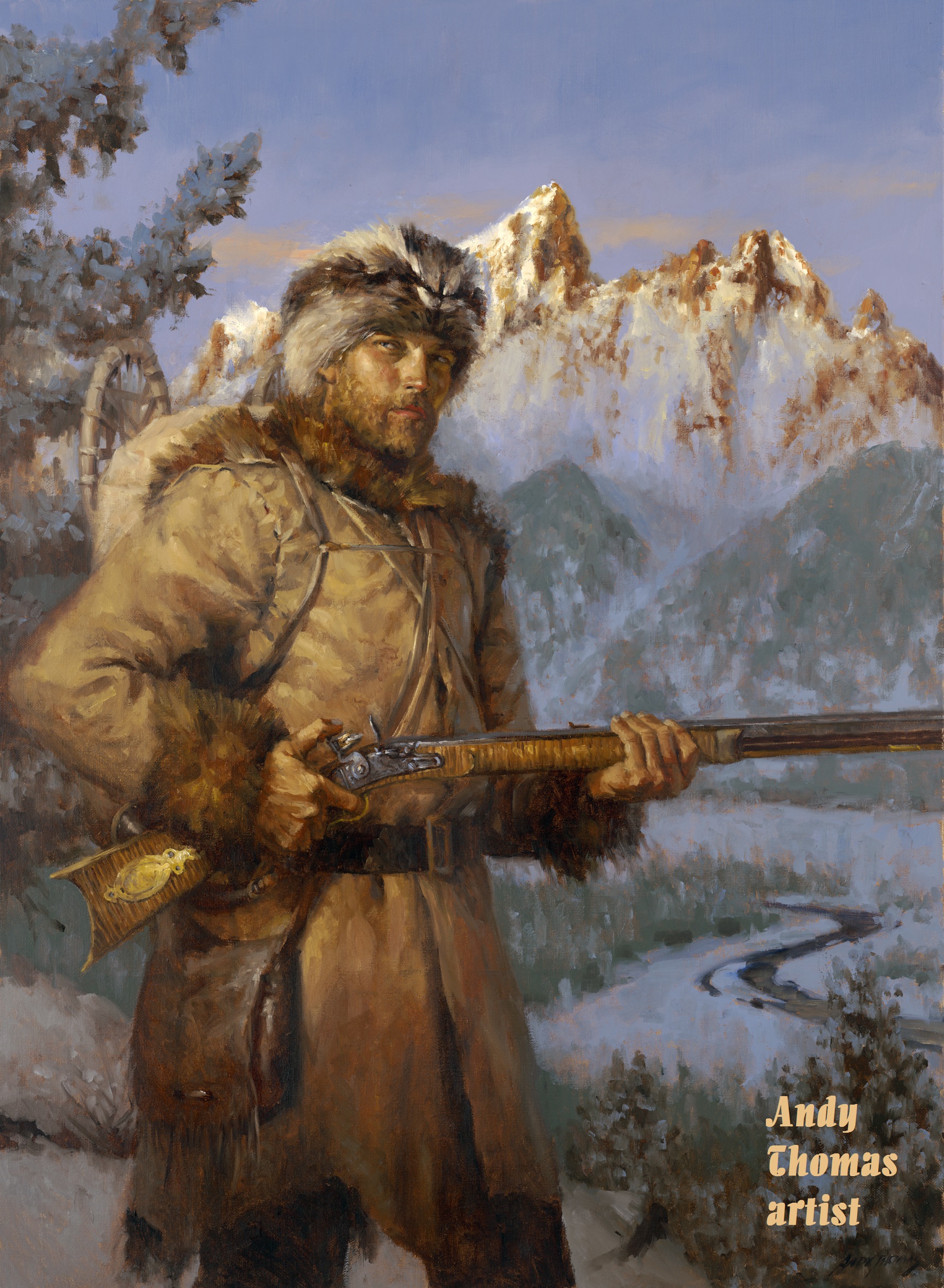
The painting below by modern-day artist Andy Thomas of Carthage, Missouri, represents John Colter. Thomas calls the image “The First Mountain Man.” This artist offers many paintings of historic people and events, and his mountain man appealed to me.

I was looking online for photos to represent my characters when I came across it.

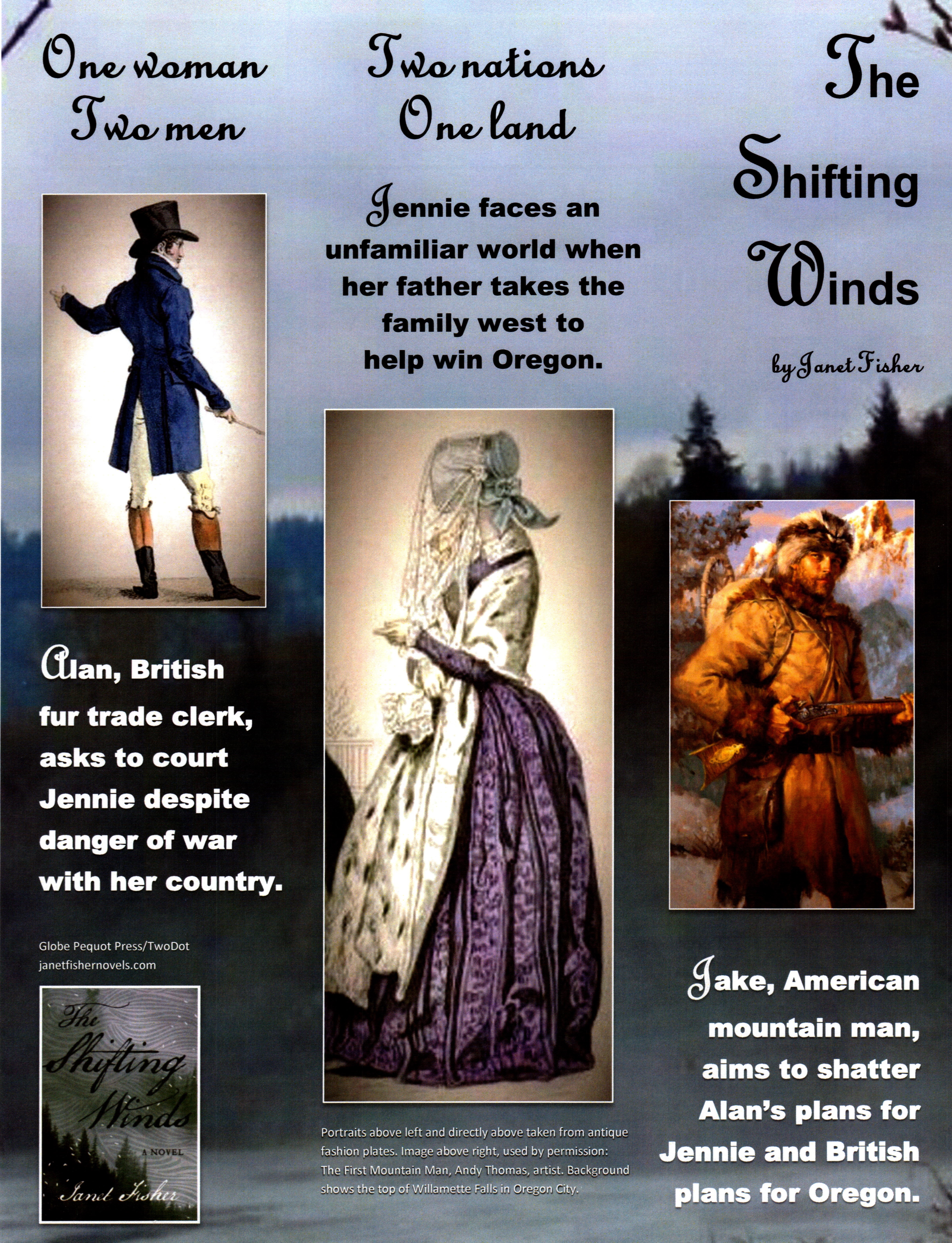
I wanted to put together a poster and banner with images portraying my protagonist, American pioneer Jennie Haviland, and the two men in Oregon who were vying for her affections, British Hudson’s Bay Company clerk Alan Radford, and American mountain man Jake Johnston.

Alan was a well-dressed gentleman of the times and I had no trouble finding an 1800s fashion plate that had the right look for him.

I found one complete with frock coat and tall beaver hat, even if the face wasn’t quite as gorgeous as I imagined him. And I found a young woman in a fashion plate with period dress, her face hidden by a bonnet so folks can imagine her appearance as they choose.

But there were no fashion plates for mountain men. Most of the mountain man pictures I found were of crusty old fellows with long, scraggly beards. Now, there may have been some mountaineers like them, but trapping in the Rockies was not a business for old men. These guys had to be tough and in their prime, and most were clean shaven.

Part of the reason for shaving was that the Native American men they associated with had little face hair and plucked what grew, so the women seeing a bearded white man might laugh disparagingly and call him a dog face. If these trappers wanted to win the hearts of these women, shaving was a good idea–not to mention the greater ease of keeping small critters out of their soup.

Anyway, I came across this image of a mountain man and it spoke to me. The guy in the painting had the gravitas I was looking for, and with the artist’s permission, John Colter now plays the role of Jake for me on my poster.

He’s also on a larger horizontal banner, and in other marketing materials for the book.

He doesn’t look exactly the way I see Jake either, but he has keen eyes that might be about to twinkle and a bit of don’t-mess-with-me attitude I can’t help but like. He’ll probably shave when he gets back to camp.

And that brings us to the real John Colter. He was born in Virginia sometime around 1775, his father evidently having come from Ireland. The family moved to the Kentucky frontier around 1780 when John was a young boy. At about 30 years of age he impressed Meriwether Lewis with his frontier skills, and Lewis recruited him for the Lewis and Clark Expedition as a private.

Colter may have been a little hotheaded because he got into a fracas with his sergeant even before they left and threatened to shoot the man, but somehow it got smoothed over and he became a valued member of the team and one of the best hunters. Lewis learned he could trust Colter to handle many difficult situations. The man showed skill in bartering with the tribes they met, and he would strike out alone wherever Lewis or Clark asked him to go and always find his way.

Two months before the end of the journey home, the expedition met some trappers headed west, and Colter joined them as a worthy addition, given his fresh knowledge of much of the territory. He went out alone for them during the winter, traveling some 500 miles through the wilderness to establish trade with the Crow nation, and was probably the first white man to see such sights as the spewing Yellowstone wonders, which came to be known as Colter’s Hell. Many stories of his skills and scrapes have been the stuff of books and movies, but probably none so dramatic as his run from the Blackfeet.

Colter was canoeing up the Jefferson River with another trapper, Potts, when several hundred Blackfeet showed up and demanded the two go ashore. The Blackfeet killed Potts in the incident, hacking him to death, then stripped Colter naked and told him to run. He soon realized they expected him to run for his life. His nose began to bleed, but he kept going as blood streamed and was well ahead of all but one of his pursuers.

With a suddenness that startled the man on his tail, Colter came to an abrupt stop and swung around to face him, arms wide. Caught by surprise at Colter’s actions, and perhaps the blood streaming over Colter’s naked body, the man also tried to stop but fell forward as he threw a spear and plunged it into the ground. Colter snatched up the broken weapon and killed him, then grabbed a blanket from him and fled the others. After a five-mile run he reached the Madison River and jumped in, taking refuge in a beaver lodge until nightfall when he escaped.

Thus he became something of a legend. When he did return to civilization a few years later he visited William Clark of the Lewis and Clark expedition and reported on his travels, adding considerable detail for Clark’s maps. He got married and farmed in Missouri awhile before fighting in the War of 1812. He never returned to the mountains.

About ten years after the war, just before Dr. John McLoughlin went out to the Columbia, some men of St. Louis, William Ashley and Andrew Henry, put together a fur company that significantly impacted the American fur trade. Prior to that time, most furs were acquired through trade with the Indians. But Ashley and Henry led their own trappers into the west, where they built a couple of forts and wintered with the Crow tribe. In the spring of 1824 the trappers went into the Green River country and found it rich in beaver. Ashley came up with a working scheme when he put together the first supply train and took the caravan to the Rockies the next summer so the trappers didn’t have to haul their furs to market in St. Louis. The annual rendezvous had begun.

amfurcaravan

The above painting by Alfred Jacob Miller shows the supply caravan bringing supplies to the Rocky Mountains for the annual rendezvous of the mountain men. Miller went out with the supply train in 1837 and created many portraits of the landscapes and mountaineers and Native Americans he saw there. The man on the white horse is the Scottish adventurer William Drummond Stewart who hired Miller to take the journey with him to record the event.

The Rocky Mountain Rendezvous lasted from 1825 until 1840 when beaver began to play out and prices dropped because men discovered silk hats to replace their beavers. It was a great run and the rendezvous an uproarious party when men let loose after they’d spent a year working hard in dangerous conditions. The supply trains brought out pure alcohol to mix with the clear water of the mountain streams, adding to the craziness. Friendly tribes gathered with the mountaineers, and many of the Americans took wives from these tribes or enjoyed temporary liaisons.

Miller greeting

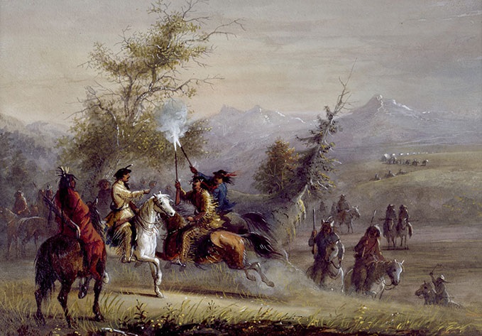
This Miller portrait shows the rip roaring greeting trappers typically gave to the arriving caravan. Again the Scot Stewart is on the white horse.

During these years the Americans pretty well kept to the Rockies, while the British reaped the Oregon Territory of beaver there. Sometimes they bumped up against each other, and competition was fierce. The British ultimately pursued a scorched earth policy to make sure there weren’t enough beaver left on the west side to lure the Americans to Oregon.

Because of the supply train system many of the American trappers never went back home, and after years of living in the wilderness, often with wives and children they knew wouldn’t be accepted in the States, they felt adrift when the mountain life ended. So after the last rendezvous of 1840 quite a few went to Oregon anyway and decided to become settlers, a situation that didn’t always set well with the British. Thus legendary mountain man Joe Meek, a major player in my book, enters the stage, along with others who are named in the pages, accompanied by the fictional Jake Johnston. This was just two years before the book’s 1842 opening.

Dr. McLoughlin, another major historic player in my book, found himself caught in a dilemma between honoring the interests of his nation and following his own humanitarian instincts.

But when the good doctor first went to the Oregon Country in 1824 the British had a near monopoly there and prospects all looked rosy.

Gowans, Fred R. Rocky Mountain Rendezvous: A History of the Fur Trade Rendezvous 1825-1840. Provo, UT: Brigham Young University Press, 1976.
Various websites.

Next: British Stronghold

COMMENT

Save

The TRUE Shifting Winds ~ 2: Fur Traders

As my upcoming July 16 book event at Fort Vancouver nears, this new blog series sets the stage for that historic place and the part it plays in my book The Shifting Winds.

The overview of the true history of the world’s shifting winds continues in this post as the unknown Pacific Northwest keeps luring explorers into the region. Of course, mere curiosity would not compel them like the hopes of gaining a new possession and the riches the land offered. While the glitter of gold may have drawn earlier navigators like the Spanish and Portuguese to the centers of their discoveries, another prize put a gleam in men’s eyes and prompted a race to win the Pacific Northwest territory.

Beaver peltsFur.

The prime fur was beaver like these pelts at right displayed in the reconstructed Fort Vancouver warehouse. Without the fur, Fort Vancouver would not have been. This was the chief bounty, thanks to the beaver hat which became a popular fashion statement in Europe and the States, as traders from two nations pressed for advantage in one land.

The Race for Possession

Thomas Jefferson had been interested in the Pacific Northwest for some time when he took office as President of the United States in 1801, but without a contiguous territory overland he was not ready to consider more than an independent state in the region. Even that he considered to be a hazardous endeavor for the young nation.

1794_Samuel_Dunn_Wall_Map_of_the_World_in_Hemispheres_-_Geographicus_-_World2-dunn-1794This 1794 double hemisphere wall map of the world, or terraqueouis globe, by Samuel Dunn shows the new discoveries and marginal delineations. From Geographicus.

So the maps they are a-changing. It’s beginning to look more familiar.

Jefferson was intrigued by the 1765 report of Major Robert Rogers, who had written of a great “River of the West, or Ouragon River” said to flow west into the Pacific Ocean, a potential northwest passage from the Atlantic to the Pacific. And by 1792 the US navigator Captain Robert Gray had already discovered and named the Columbia River. Soon afterward British Lieutenant William Broughton, under the command of Captain George Vancouver, had sailed some 120 miles upriver.

But the condition of the Columbia beyond that point remained an unknown to these explorers. Was it the River of the West? The Ouragon? Or the Oregon? And would it allow direct transportation—or at least an easy portage—to a navigable river flowing east to the Atlantic, essentially the sought after northwest passage?

1794_Samuel_Dunn_Wall_Map_of_the_World_in_Hemispheres_-_Geographicus_-_World2-dunn-1794 (crop) (4)Zooming in on Dunn’s above map you can see two Rivers of the West flowing into the Pacific. Perhaps folks were still trying to decide, or hedging their bets.

Meanwhile Canadian fur traders had begun to consider the overland route to the Pacific. Alexander Mackenzie, a partner in the Canadian North West Company, became a firm skeptic of the northwest passage after following a large river into the northern interior in hopes of locating the mythical route, only to find that this river emptied into the Arctic. Convinced that no northwest passage for sea vessels existed, he insisted if Canadians wanted to reach the Pacific from Hudson’s Bay they should go overland.

Mackenzie organized an expedition to do just that, intending to cross the Rockies, then go down the River of the West. His party came across a major waterway, which he assumed to be this elusive stream, but he discovered it was not the river dubbed Columbia by the American Captain Gray, but a more northerly river which would be named the Fraser. Mackenzie’s party reached the coast at Port Meares in July 1793 after a harrowing journey, the first transcontinental crossing north of Mexico.

Jefferson must have been pondering all this when the international winds shifted again, and Napoleon’s dilemma became Jefferson’s boon. The United States had been negotiating with France for New Orleans, because the Americans wanted the mouth of the Mississippi. But when the entirety of the Louisiana Territory, once a French possession, was dropped back into Napoleon’s lap through various treaties, he knew he was no longer in a position to protect it, and he greatly feared that his arch enemy, the British, now ensconced in Canada, would ultimately take it from him.

Jefferson was just as fearful at the prospect of the powerful French on his border, but he didn’t want to make this longtime friend an adversary. He was surprised when Napoleon offered to sell the Louisiana Territory to the United States for a song, and suddenly the fledgling US nation nearly doubled its size.

Lewis & Clark 2The Great Explorers – Lewis & Clark: Halftone reproduction of drawing by Frederic Remington in Collier’s Magazine, 1906 May 12, from Library of Congress.

The Americans didn’t know much about the Louisiana Territory, not even the boundaries on the north and south, though its western boundary lay somewhere along the crest of the Rockies. Louisiana now provided that contiguous link with the territory of the west. So Jefferson sent out Meriwether Lewis and William Clark to see what the United States had bought and to explore and map the region. However, he didn’t want them to stop at the western edge of the newly acquired Louisiana, but to continue into the west to explore that land of uncertain possession, including the intriguing river their compatriot Gray had discovered.

Leaving St. Louis in the spring of 1804, Lewis and Clark proceeded up the Missouri River, crossed the Rocky Mountains and came down the Clearwater River to the Snake before making their way into the Columbia River, which they navigated all the way out to Young’s Bay. The Columbia proved to be a magnificent waterway, but not a northwest passage, given the ruggedness of the land between it and the east flowing streams. A young member of the expedition named John Colter would later gain fame for adventures upon his return into the mountains to look for furs, leading many to call him the first mountain man. More about him in the next post.

When Lewis and Clark returned to the States in 1806, Americans became excited about commercial possibilities in the west. Fur dealer John Jacob Astor approached the North West Company about joining forces, but when they refused, he founded his own Pacific Fur Company. He sent out two parties to the Columbia, one by land, led by Wilson Price Hunt, and one by sea aboard the Tonquin.

Men from the Tonquin arrived in the Columbia in March 1811 and set up a trading post on the south bank, naming it Fort Astoria. The overland party straggled in almost a year later after a grueling trek.

FortAstoria1813The above 1813 sketch of Fort Astoria was created by Gabriel Franchère, one of Astor’s men from the Tonquin, and later published in 1819 with Franchère’s account of the venture.

At about the same time, the Canadian North West Company sent David Thompson over the mountains to establish fur trading posts and continue to the mouth of the Columbia. The Astorians offered Thompson a friendly greeting, but the War of 1812 erupted, putting the men on opposite sides of the conflict. Through a complicated series of events, the fort of Astoria was sold under some duress and turned over to the Canadians. A British warship, the HMS Raccoon, entered the Columbia soon afterward, its captain hoping to capture the fort, but the sale had already occurred.

Author Robert C. Johnson, in his book John McLoughlin, describes the disappointment of the warship’s Captain William Black when he saw Fort Astoria. “‘What! Is this the fort I have heard so much of?’ exclaimed Black. ‘Good God, I could batter it down with a four-pounder in two hours.'” He took possession and renamed it Fort George after the British king.

When this news reached Astor in New York he was not pleased, but the deed was done. Given the remoteness of the fort, its sale and surrender were unknown to negotiators of the Treaty of Ghent ending the war in 1814. The treaty provided that territory and possessions taken by one nation from the other should be restored. Because of this agreement, the British were expected to restore Fort George to the Americans. However, a question remained as to whether the fort was taken or sold. That and other controversies between the nations led to another treaty in 1818 to settle the boundary issues in the region.

Spain and Russia also came into the question, but the United States was haggling with Spain over Florida and didn’t want to press too hard on the southern boundary with Spain, though the line was established the next year at the 42nd parallel. Russia was pushing for a boundary in the north where they would take all territory down to the 51st, but neither Britain or the United States would accept that and finally negotiated it back to 54-40. With Spain and Russia settled, that left the Americans and the British.

The US claim to the territory was founded on Gray’s discovery of the Columbia, the Lewis and Clark expedition, the founding and restoring of Astoria, and the title acquired from Spain. After settling with the Spanish, the United States contended that any rights Spain possessed as a result of discovery had passed to the United States. The British claim was based on early voyages along the northwest coast, land exploration by Mackenzie, North West Company posts on the Columbia and Fraser Rivers, and Broughton’s ascent up the Columbia River.

The 1818 treaty set the boundary between Britain and the United States at the 49th parallel from the Lake of the Woods to the Stony Mountains, the Rockies, each nation ceding some land to make a straight border, but at the Rockies they hit a snag. Americans suggested continuing the 49th parallel to the coast, though many of their countrymen wanted to push the British north all the way to 54-40. Britain wanted the boundary to drop southward and follow the Columbia River so they could retain the lucrative fur trade there. With the two sides unable to agree, the treaty declared that the Oregon territory be jointly occupied between the United States and Britain for 10 years, giving them time to settle on a boundary between them. The treaty allowed both nations the right of settlement and trade, but neither could claim title to the land. Agreement would take much longer than 10 years.

While the Americans and British hassled over the details of negotiation, another virtual war raged between the Montreal-based North West Company and the other major British fur company doing business in the region, the London-based Hudson’s Bay Company, resulting in the deaths of many trappers and traders. To end hostilities the beleaguered companies finally merged in 1821 under the Hudson’s Bay Company.

The history of the restoration of Fort George (Astoria) to the United States seems a little murky. As the 1818 treaty was concluding, a representative of the US government arrived at the fort to receive the fort’s surrender, and the US flag was raised. By some accounts, as soon as the US representative sailed away, the US flag came down. In any case, the Canadian North West Company continued to maintain the post, perhaps for lack of further US action, and when that company ceased to exist, the British Hudson’s Bay Company took it over, more or less by default.

Dr. John McLoughlin, formerly an employee of the North West Company, became a Hudson’s Bay Company man and was assigned in 1824 as commander of the HBC western district. He would soon make a grand entry at Fort George.

Carey, Charles H., LLD. General History of Oregon: Through Early Statehood. Portland, OR: Binfords & Mort, 1971.
Johnson, Robert C. John McLoughlin: “Father of Oregon.” Portland, OR: Binfords & Mort, 1958.
Various websites.

Next: Mountain Men

COMMENT