The TRUE Shifting Winds ~ 5: Digging Up the Past

I first visited Fort Vancouver some years ago to research a short segment for one of my early attempts at an Oregon Trail novel, and the place put me right back in time. I was so inspired by the authentic reproduction of this historic fort I knew I had to write another book with more scenes set there. That became The Shifting Winds, which I’m honored to be presenting at the fort this Saturday, July 16, at 2 pm.

In this post I want to talk about how this wonderful reconstruction came to be.

Archaeology and Record Keepers

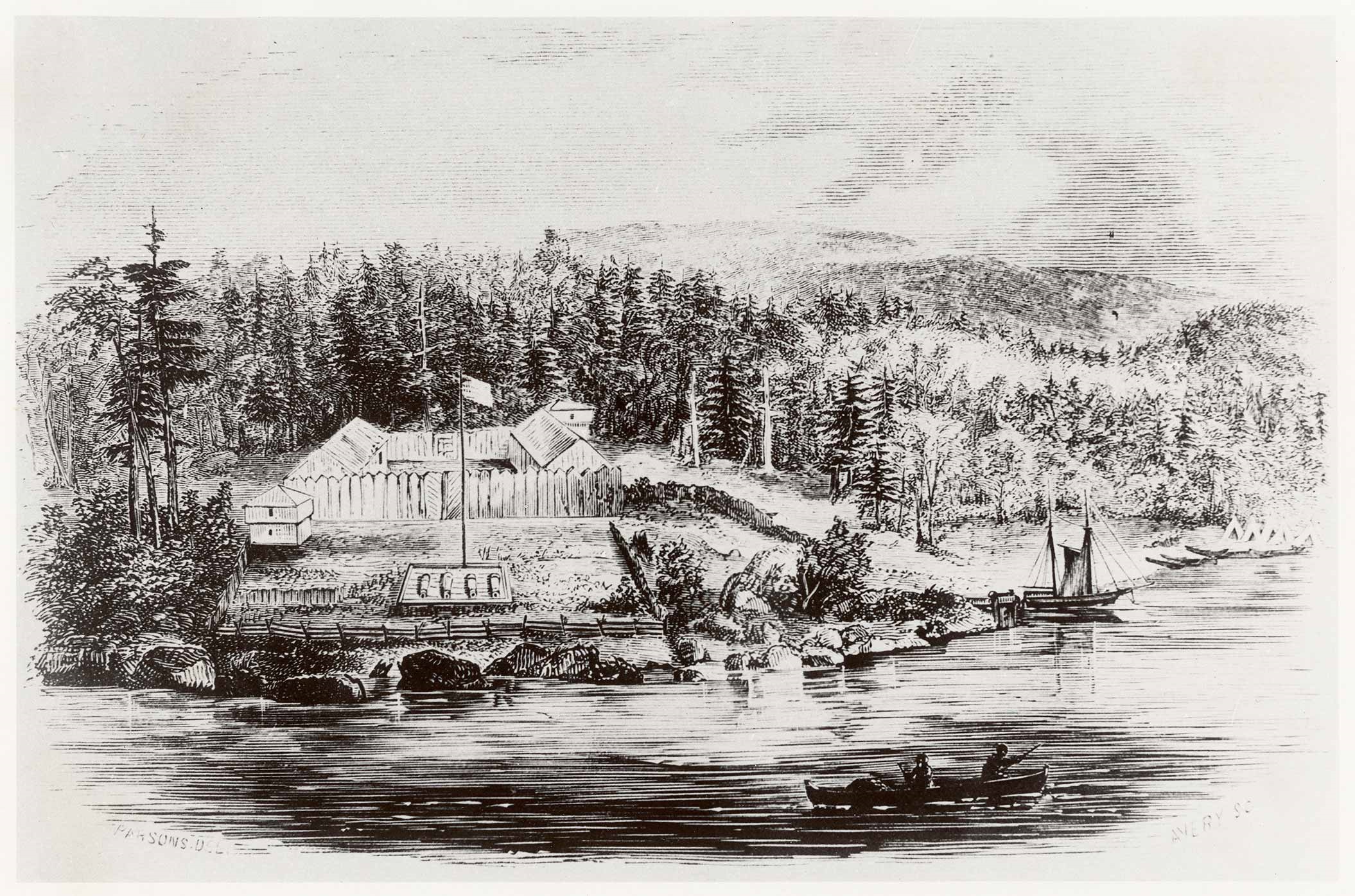
The British Hudson’s Bay Company chose a location on the north bank of the Columbia River for their western headquarters in the Oregon Country because they felt optimistic about Britain holding land on that side of the river once London and Washington agreed on a boundary between the two nations. But in 1824 when Dr. John McLoughlin and his boss Governor George Simpson selected the site, enough uncertainty hung over the region that they didn’t want to make a huge investment.

Also unsure of the friendliness of the local tribes, they erected the first palisade walls about a mile inland, creating a simple fur trading post on a bluff about a mile from the river with bastions on at least two corners, ready to defend themselves against attack.

Several events came together to change their perspective. First, the joint occupancy treaty of 1818 between the British and the United States was extended indefinitely in 1827. The Native Americans proved to be agreeable traders, and the distance from the river proved to be a bloody nuisance.

So in 1828 they pulled up stakes, literally, and moved the whole thing a mile closer to the river to the spot where the reconstructed fort lies today.

Christened in 1829, the new fort would serve the Company for many years. But it didn’t remain static. It kept changing over time like a living, breathing organism that sloughs off old skin while growing new. The fort walls kept moving. The fort doubled in size by 1836. Apparently the officers found their space too small.

They would expand again, moving the south wall farther out—and the east wall—again.

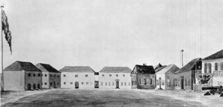
Buildings changed. The first Big House in the original west half began to sag until someone described its condition as so dilapidated it was ready to fall down around them. They rebuilt a new Big House in the east half where you can see it reconstructed today.

So why the reconstruction? Why did the original disappear? And why the constant change?

In short, wood rots—especially in a place where rain soaks the land for more than half the year. And little critters move in to feed on wood fiber.

Constant maintenance was required, and sometimes they just tore down buildings and constructed new. They continually replaced rotting pickets in the stockade and repaired leaky roofs. When the British finally lost the land on which the fort stood—as you must know they did—the Hudson’s Bay Company was allowed to stay on for a while, but they soon began moving the bulk of their business to Fort Victoria. London and Washington had finally agreed on a border in 1846, drawing the line along the 49th parallel, well north of Fort Vancouver, although giving the British Victoria along with the entirety of Vancouver Island.

By 1860 the Company abandoned the fort and the United States Army assumed control. But they found most of the buildings unsuitable for their purposes and in dilapidated condition. In a few years rot and fire destroyed what was left.

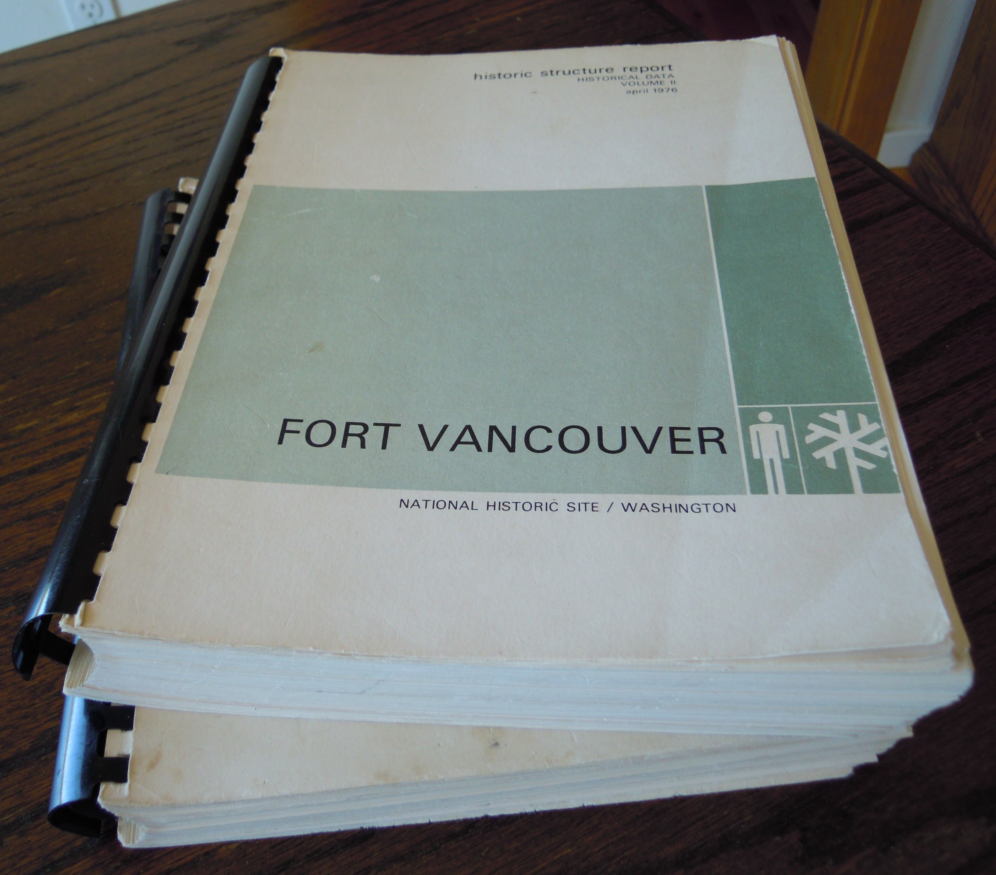
Yet some historians didn’t forget. In the 1940s the National Park Service began exploring the possibility of reconstruction. If they were going to do it they wanted to do it right. On my first visit to the reconstructed fort in the 1980s a curator there loaned me these two large volumes of a “Historic Structures Report” by John A. Hussey and the historic preservation team.

The volumes described the detailed research that went into this re-creation, a wealth of information. When I called about returning the volumes, the curator told me that if I continued to find them useful I should keep them because they had plenty of copies. What a boon to my research!

Now of course the report is online, offering a glimpse of the magnitude of the project. But I have spent many hours poring over the printed books.

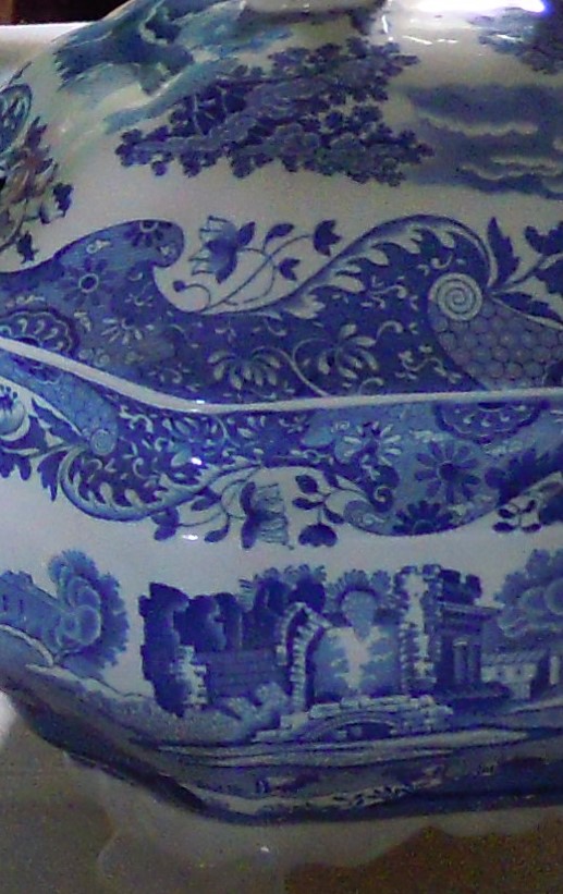
As early as 1947 National Park Service archeologists dug into the soil to find footings of buildings and remains of those moving walls at their various locations. They found tools, pottery, even Spode china on the site of the Big House–something in blue on white, perhaps to match these on display in the Big House dining hall, or Mess Hall, like the one shown here. Meanwhile, researchers looked into records. The Hudson’s Bay Company, still a functioning business in the UK, generously opened their remarkable archives for this study.

The British had kept detailed records.

Researchers were also given access to similar HBC posts, now in Canada, and those were studied and photographed for comparison. The Company tended to follow similar plans from one fort to another, so those helped in decisions about the finer points.

Books written in the day offered observations of the fort. Libraries across the United States and Canada held useful tidbits. Many fort visitors wrote about their impressions, sometimes drawing detailed sketches and maps. These were often dated and helped show the constant rearrangements going on over the fort’s life. Researchers scrutinized maps, drawings, every descriptive statement they could find. Much of that went into this report, along with bits of story that add flavor.

Warre Lithograph-1

The above lithograph was based on a water color by Henry J. Warre painted during his 1845 visit. My thanks to Meagan Huff, assistant curator at the fort, for sending me this copy from the National Park Service collection. She pointed out a change the artists in London made to Warre’s original.

Warre’s original gives us these characters.

Did Warre depict shepherds? Or voyageurs? Perhaps wanting the image more colorful the London artists replaced the original figures in the foreground with Native Americans, but in Plains tribe dress, not realizing that these tribes did not frequent the area.

Because the fort changed so much from year to year, the preservation team needed to pick a date, and they decided to reconstruct to the year 1845. That’s close to the date of my novel, which has scenes at the fort in 1842 and 1843. So as I read the report I had to make careful distinctions between the 1845 fort I saw and the 1842 fort I would describe

For instance, in one scene Dr. McLoughlin and my fictional clerk Alan walk across the grounds from the Big House to the Indian Trade Store in the western courtyard. Today you’ll find that store on the east side, almost straight across from the Big House, a short walk. But in 1842 that store was over in the western side where the Fur Store stands today. A longer stroll.

Perhaps the most conspicuous difference would be the bastion you can see in Warre’s 1845 image above. There was no bastion in 1842, so you won’t find reference to a bastion in the book. But I have shown it in blog and Facebook posts because it looks so fort-like. Fort Vancouver was more trading post and supply depot than fortress. Caution required walls but not big guns.

The bastion went up in 1844, not because of danger, but because of protocol.

Hussey relays the story in the report. A ship sailed up the Columbia in 1844 and offered a  7-gun salute. But the fort couldn’t answer the salute because they had no cannons mounted for action.

Although they’d put up bastions on the old fort, they hadn’t bothered with a bastion in the new fort, things being so peaceful. But not to be able to answer a salute—well, that just wouldn’t do. So they built one.

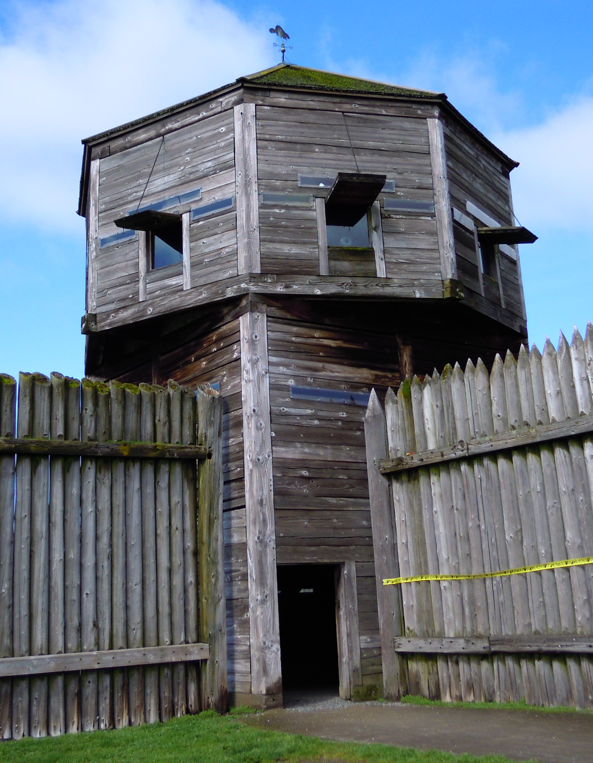
Given the troublesome nature of some of the pesky Americans coming into the country it seemed a good idea anyway.

Another change was the New Office, built in 1845 to replace the Old Office. The Old Office was one of the oldest buildings of the fort, the first thing constructed, given its function so vital to the fort’s purpose. That Old Office still served the fort in 1845, because the new one offered temporary living quarters for a ship captain who stayed on for a while, adding excitement for the gentlemen with his many parties in the new structure. This New Office, or “Counting House” as it was sometimes called, has been reconstructed. The Old Office has not, although perhaps one day it will be. It stood close by its replacement at least until 1847 when the good captain departed. The old building with its dark exterior shows clearly in a water color sketch drawn in 1846 or 1847.

The fort required considerable bookkeeping. Clerks like my fictional Alan Radford generally entered service through apprenticeship, nearly all of them from Britain. Because of the many applicants, family connections helped. These clerks were usually well educated and knew some accounting beforehand. The Company wanted reliable, loyal clerks working in the office, men who would be discreet and keep Company business confidential. These accounting clerks held one of the better paid jobs for gentlemen at the fort.

I took particular interest in the office, given that Alan is a major player in my book. Other buildings of special interest to me were the Big House where Jennie stays during her visit for the Christmas Ball and where the ball takes place, and the Bachelor’s Quarters where American mountain man Jake Johnston stays, having joined the party for his own reasons. Accountants like Alan lived in the office, but most clerks lived in the Bachelor’s Quarters, a long building divided into multiple rooms or apartments. And when gentlemen came to visit, the clerks often got bumped to accommodate the visitors.

However, Alan appeared none too pleased when McLoughlin allowed Jake a room in the Bachelor’s Quarters. When Jennie asked Jake what was wrong with Alan, Jake grinned.

“Well,” he said, “it’s only gentlemen who are allowed to stay inside the fort, and I don’t think Radford considers me a gentleman.”

She wasn’t sure Jake was a gentleman either, but she was surprised at the rigidity.

The Bachelor’s Quarters have not been reconstructed yet either, but the report offers excellent detail.

Fisher, Janet. The Shifting Winds. Guilford, CT, Helena, MT: TwoDot, Globe Pequot Press, Rowman & Littlefield, 2016.
Hussey, John A. Historical Structures Report Historical Data, Vol. I and II. Denver Service Center, National Park Service, U.S. Department of the Interior, 1972, 1976.

Next: Making the Past Live

COMMENT

The TRUE Shifting Winds ~ 4: British Stronghold

So enters the venerable Dr. John McLoughlin onto our Oregon stage, just six years after the 1818 treaty which declared that the United States and Britain should jointly occupy the Oregon territory until they could stop bickering and agree on a line between them in that disputed land.

In this overview of history behind my story in the historical novel The Shifting Winds, we nudge ever closer to the volatile contention between these two nations that resonates through the book’s pages.

Dr. McLoughlin’s Oregon Reign

As mentioned in the last post, the Canadian North West Company, which had bought the US Fort Astoria, stayed on at the post despite terms of the 1814 Treaty of Ghent that ended the War of 1812. Due to the remoteness of this fort at the mouth of the Columbia River, negotiators didn’t know about the sale, and the fort came under terms that all property taken during the war be restored to the original possessor. The restoration became a murky point of history.

John McLoughlin DaguerreotypeWhatever the case, when Dr. McLoughlin of the British Hudson’s Bay Company comes onstage, his company has assumed possession by default of Fort Astoria, now called Fort George by the British in honor of their king.

The British knew how to make an entry.

The daguerreotype shows McLoughlin when he’s a little older than the day he first arrived at Fort George, but he carried himself with this powerful presence throughout his career. Photo courtesy of the National Park Service.

McLoughlin arrived at Fort George in full color display in a line of brightly decorated canoes along with his boss, Deputy Governor of the HBC, George Simpson.

Author Johnson describes the scene in his book John McLoughlin. As the flotilla of canoes approached, a sentry at the fort fired a signal gun. From the flotilla a bugle answered, followed by a piper in full Highland dress playing a march of the clans, “‘Si Coma Leum Cradh Na Shee,’ (Peace if you will it, otherwise war).”

The fort responded with a seven-gun salute.

The piper played until the paddlers brought Simpson’s lead canoe to a stop. Then the bugler in McLoughlin’s canoe played a lively chanson. The canoes formed a line offshore, made a smart turn toward the receiving party, then moved as one toward the landing, where the men embarked and joined a procession with McLoughlin and Simpson in the lead.

Many old friends in the fur trade welcomed McLoughlin, a formidable figure in stark contrast to his superior officer, Simpson. McLoughlin was six foot four, well built, his hair almost white even then at the age of 40. His piercing gray-blue eyes could rivet on a person, his clean-shaven face readily turning florid with anger or excitement. Simpson was just over five feet and plump.

Back in 1803 at age 14 McLoughlin had become a medical student in Quebec and obtained a license to practice medicine and surgery when he was all of 19.

Author Johnson relays a story of uncertain merit about McLoughlin that may have changed the direction of his life. While working as a doctor in Quebec, McLoughlin is said to have been walking with a young lady through the muddy streets of that city on a fine spring day. They stepped onto a plank at an intersection to avoid the mud, and a drunken British officer forced the young lady off the plank into the muck. McLoughlin picked up the officer and tossed him into the street.

This insult on “his majesty’s uniform” could have subjected McLoughlin to prosecution, and he supposedly fled into upper Canada.

Whether this incident or something else drew McLoughlin away from Quebec, he found employment as a physician at Fort Williams, a North West Company trading post. McLoughlin soon discovered he had an aptitude for business, and by 1814 he became a partner in the company. Still, he would find his medical skills valuable more than once when he worked at posts with no other doctor.

Somewhere in there, he had a son through a liaison with a Native American woman, “observing the custom of the country,” Johnson writes, meaning the relationship like so many others in that time and place lacked the benefit of clergy, also called a “country marriage” or “fur trade marriage.” Evidently the mother died and McLoughlin took another wife in the custom of the country, Marguerite Wadin McKay, a woman who would follow him to Oregon and happily grow old with him.

Marguerite’s father was one of the original North West Company partners, her mother of Cree heritage. She had previously married Alexander McKay, a Canadian member of Astor’s team who was killed in an incident on Astor’s ship, the Tonquin. Given the dates of events, McKay had probably abandoned her by the time she married McLoughlin, but she had three children by McKay, including Tom McKay who would come to play a significant role in the history of the Oregon country. By the time McLoughlin left for Oregon he and Marguerite had four children together.

Fort George didn’t impress McLoughlin or Simpson as an adequate western headquarters for the Hudson’s Bay Company, a major problem being its location on the south side of the river. From word of London’s offers in boundary negotiations, they feared that everything south of the Columbia River would ultimately go to the Americans. McLoughlin also wanted to make his headquarters as self-sufficient as possible, so he needed fertile land to grow food.

Nancy Funk, wearing period clothing, takes care of a garden at the Fort Vancouver National Historic Site in Vancouver, Washington. (Troy Wayrynen/picturesbytroy)
Nancy Funk, wearing period clothing, takes care of a garden at the Fort Vancouver National Historic Site in Vancouver, Washington. (Troy Wayrynen/picturesbytroy). Photo courtesy of the National Park Service.

Going upstream, McLoughlin found a site on the north bank that offered all he had hoped for. A rich wide plain spread inland from the river. Here he could grow wheat and vegetables, fruit orchards and vineyards, and improve pasture for cattle. He ordered his men to start building a fort and dubbed it Fort Vancouver for the British navigator Captain George Vancouver who’d sent one of his ships up the Columbia shortly after the American Captain Robert Gray dipped into the estuary and named the river. McLoughlin was happy to note that the site of his new fort lay downriver from the highest ascent of the British ship. McLoughlin would soon have the original stockade moved closer to the river for convenience. And from that fort, which has been replicated on the same spot today, he ran the western fur trade empire for his Company, becoming de facto ruler of Oregon.

It might have seemed his land to hold, but not quite so. By treaty the United States held equal interest through joint occupancy. Their citizens just weren’t around much at the beginning.

Joint occupancy of the Oregon country formed a tenuous marriage of Britain and the United States. Both had sought to claim the land. By sea, their navigators explored the coast, with the American guy discovering and naming the Columbia, the British guy sailing farther upstream. By land, Lewis and Clark showed the way through the new US territory of Louisiana, while the Canadian Mackenzie marked a trail farther to the north. And when Astor ventured into the Columbia to start his fur enterprise, the Canadian Thompson trekked out to Fort Astoria to say hello and set up posts along his route, eventually acquiring Astor’s fort for his own North West Company.

Fighting fury between the two nations rose in the War of 1812 for a host of reasons, but Oregon was a prize both still sought. Negotiators for peace finally threw up their hands. It took a second treaty in 1818 to come up with a halfway measure, at which time negotiators told the squabbling nations they could both use the land until they made up and set a line between them. They were given ten years for that, but in the end it would take them almost thirty, and rumors of another war over the matter continued to stir.

OregonTerritoryMap1818This 1833 map roughly shows the extent of the Oregon territory in 1818. It includes all of today’s Oregon, Washington, and Idaho, with parts of Montana and Wyoming, and runs north into British Columbia.

For twenty years or so while the United States became attracted to other shiny objects closer to home, the powerful British Hudson’s Bay Company seemed bent on making Oregon their own private fur reserve under McLoughlin’s adept leadership.

By 1842 when my story opens, the Americans seemed finally to awaken to the desirability of adding the Oregon country to their own. American trappers began to settle in Oregon’s broad valleys around 1840 when the Rocky Mountain fur trade petered out. Missionaries had gone out to save the Indians in the 30s and reported on the richness of the land. Promoters called on the adventurous to strike out across the plains and take up some of that land virtually flowing with milk and honey. They played down the difficulty of the trail–most hadn’t a clue–as they extolled the wonders of the Promised Land at trail’s end.

Native Americans received little consideration. Disease had dramatically reduced their numbers, and the British under McLoughlin’s firm hand kept the peace. Trade with the local tribes was key to the business operation of the HBC.

As more Americans trickled into the area, tensions rose. American farmers and lawyers and storekeepers came with their families, intending to settle and stay. Settlement hadn’t been encouraged by the British during the early days of joint occupancy, but they did eventually encourage settlement north of the Columbia as a counterbalance. Up until that time few white women came to Fort Vancouver. British and French-Canadian men found their wives among the surrounding tribes, or brought their Native American or Métis wives from Canada. Most expected to return to the place they had enlisted with the Company, though a few had chosen to settle in the Willamette Valley, McLoughlin keeping them on the Company books so they didn’t have to go.

The encroachment of permanent US settlers into Oregon brought troubling headaches for the good doctor, McLoughlin.

Carey, Charles H., LLD. General History of Oregon: Through Early Statehood. Portland, OR: Binfords & Mort, 1971.
Johnson, Robert C. John McLoughlin: “Father of Oregon.” Portland, OR: Binfords & Mort, 1958.
Various websites.

Next: Digging Up the Past

COMMENT

The TRUE Shifting Winds ~ 2: Fur Traders

As my upcoming July 16 book event at Fort Vancouver nears, this new blog series sets the stage for that historic place and the part it plays in my book The Shifting Winds.

The overview of the true history of the world’s shifting winds continues in this post as the unknown Pacific Northwest keeps luring explorers into the region. Of course, mere curiosity would not compel them like the hopes of gaining a new possession and the riches the land offered. While the glitter of gold may have drawn earlier navigators like the Spanish and Portuguese to the centers of their discoveries, another prize put a gleam in men’s eyes and prompted a race to win the Pacific Northwest territory.

Beaver peltsFur.

The prime fur was beaver like these pelts at right displayed in the reconstructed Fort Vancouver warehouse. Without the fur, Fort Vancouver would not have been. This was the chief bounty, thanks to the beaver hat which became a popular fashion statement in Europe and the States, as traders from two nations pressed for advantage in one land.

The Race for Possession

Thomas Jefferson had been interested in the Pacific Northwest for some time when he took office as President of the United States in 1801, but without a contiguous territory overland he was not ready to consider more than an independent state in the region. Even that he considered to be a hazardous endeavor for the young nation.

1794_Samuel_Dunn_Wall_Map_of_the_World_in_Hemispheres_-_Geographicus_-_World2-dunn-1794This 1794 double hemisphere wall map of the world, or terraqueouis globe, by Samuel Dunn shows the new discoveries and marginal delineations. From Geographicus.

So the maps they are a-changing. It’s beginning to look more familiar.

Jefferson was intrigued by the 1765 report of Major Robert Rogers, who had written of a great “River of the West, or Ouragon River” said to flow west into the Pacific Ocean, a potential northwest passage from the Atlantic to the Pacific. And by 1792 the US navigator Captain Robert Gray had already discovered and named the Columbia River. Soon afterward British Lieutenant William Broughton, under the command of Captain George Vancouver, had sailed some 120 miles upriver.

But the condition of the Columbia beyond that point remained an unknown to these explorers. Was it the River of the West? The Ouragon? Or the Oregon? And would it allow direct transportation—or at least an easy portage—to a navigable river flowing east to the Atlantic, essentially the sought after northwest passage?

1794_Samuel_Dunn_Wall_Map_of_the_World_in_Hemispheres_-_Geographicus_-_World2-dunn-1794 (crop) (4)Zooming in on Dunn’s above map you can see two Rivers of the West flowing into the Pacific. Perhaps folks were still trying to decide, or hedging their bets.

Meanwhile Canadian fur traders had begun to consider the overland route to the Pacific. Alexander Mackenzie, a partner in the Canadian North West Company, became a firm skeptic of the northwest passage after following a large river into the northern interior in hopes of locating the mythical route, only to find that this river emptied into the Arctic. Convinced that no northwest passage for sea vessels existed, he insisted if Canadians wanted to reach the Pacific from Hudson’s Bay they should go overland.

Mackenzie organized an expedition to do just that, intending to cross the Rockies, then go down the River of the West. His party came across a major waterway, which he assumed to be this elusive stream, but he discovered it was not the river dubbed Columbia by the American Captain Gray, but a more northerly river which would be named the Fraser. Mackenzie’s party reached the coast at Port Meares in July 1793 after a harrowing journey, the first transcontinental crossing north of Mexico.

Jefferson must have been pondering all this when the international winds shifted again, and Napoleon’s dilemma became Jefferson’s boon. The United States had been negotiating with France for New Orleans, because the Americans wanted the mouth of the Mississippi. But when the entirety of the Louisiana Territory, once a French possession, was dropped back into Napoleon’s lap through various treaties, he knew he was no longer in a position to protect it, and he greatly feared that his arch enemy, the British, now ensconced in Canada, would ultimately take it from him.

Jefferson was just as fearful at the prospect of the powerful French on his border, but he didn’t want to make this longtime friend an adversary. He was surprised when Napoleon offered to sell the Louisiana Territory to the United States for a song, and suddenly the fledgling US nation nearly doubled its size.

Lewis & Clark 2The Great Explorers – Lewis & Clark: Halftone reproduction of drawing by Frederic Remington in Collier’s Magazine, 1906 May 12, from Library of Congress.

The Americans didn’t know much about the Louisiana Territory, not even the boundaries on the north and south, though its western boundary lay somewhere along the crest of the Rockies. Louisiana now provided that contiguous link with the territory of the west. So Jefferson sent out Meriwether Lewis and William Clark to see what the United States had bought and to explore and map the region. However, he didn’t want them to stop at the western edge of the newly acquired Louisiana, but to continue into the west to explore that land of uncertain possession, including the intriguing river their compatriot Gray had discovered.

Leaving St. Louis in the spring of 1804, Lewis and Clark proceeded up the Missouri River, crossed the Rocky Mountains and came down the Clearwater River to the Snake before making their way into the Columbia River, which they navigated all the way out to Young’s Bay. The Columbia proved to be a magnificent waterway, but not a northwest passage, given the ruggedness of the land between it and the east flowing streams. A young member of the expedition named John Colter would later gain fame for adventures upon his return into the mountains to look for furs, leading many to call him the first mountain man. More about him in the next post.

When Lewis and Clark returned to the States in 1806, Americans became excited about commercial possibilities in the west. Fur dealer John Jacob Astor approached the North West Company about joining forces, but when they refused, he founded his own Pacific Fur Company. He sent out two parties to the Columbia, one by land, led by Wilson Price Hunt, and one by sea aboard the Tonquin.

Men from the Tonquin arrived in the Columbia in March 1811 and set up a trading post on the south bank, naming it Fort Astoria. The overland party straggled in almost a year later after a grueling trek.

FortAstoria1813The above 1813 sketch of Fort Astoria was created by Gabriel Franchère, one of Astor’s men from the Tonquin, and later published in 1819 with Franchère’s account of the venture.

At about the same time, the Canadian North West Company sent David Thompson over the mountains to establish fur trading posts and continue to the mouth of the Columbia. The Astorians offered Thompson a friendly greeting, but the War of 1812 erupted, putting the men on opposite sides of the conflict. Through a complicated series of events, the fort of Astoria was sold under some duress and turned over to the Canadians. A British warship, the HMS Raccoon, entered the Columbia soon afterward, its captain hoping to capture the fort, but the sale had already occurred.

Author Robert C. Johnson, in his book John McLoughlin, describes the disappointment of the warship’s Captain William Black when he saw Fort Astoria. “‘What! Is this the fort I have heard so much of?’ exclaimed Black. ‘Good God, I could batter it down with a four-pounder in two hours.'” He took possession and renamed it Fort George after the British king.

When this news reached Astor in New York he was not pleased, but the deed was done. Given the remoteness of the fort, its sale and surrender were unknown to negotiators of the Treaty of Ghent ending the war in 1814. The treaty provided that territory and possessions taken by one nation from the other should be restored. Because of this agreement, the British were expected to restore Fort George to the Americans. However, a question remained as to whether the fort was taken or sold. That and other controversies between the nations led to another treaty in 1818 to settle the boundary issues in the region.

Spain and Russia also came into the question, but the United States was haggling with Spain over Florida and didn’t want to press too hard on the southern boundary with Spain, though the line was established the next year at the 42nd parallel. Russia was pushing for a boundary in the north where they would take all territory down to the 51st, but neither Britain or the United States would accept that and finally negotiated it back to 54-40. With Spain and Russia settled, that left the Americans and the British.

The US claim to the territory was founded on Gray’s discovery of the Columbia, the Lewis and Clark expedition, the founding and restoring of Astoria, and the title acquired from Spain. After settling with the Spanish, the United States contended that any rights Spain possessed as a result of discovery had passed to the United States. The British claim was based on early voyages along the northwest coast, land exploration by Mackenzie, North West Company posts on the Columbia and Fraser Rivers, and Broughton’s ascent up the Columbia River.

The 1818 treaty set the boundary between Britain and the United States at the 49th parallel from the Lake of the Woods to the Stony Mountains, the Rockies, each nation ceding some land to make a straight border, but at the Rockies they hit a snag. Americans suggested continuing the 49th parallel to the coast, though many of their countrymen wanted to push the British north all the way to 54-40. Britain wanted the boundary to drop southward and follow the Columbia River so they could retain the lucrative fur trade there. With the two sides unable to agree, the treaty declared that the Oregon territory be jointly occupied between the United States and Britain for 10 years, giving them time to settle on a boundary between them. The treaty allowed both nations the right of settlement and trade, but neither could claim title to the land. Agreement would take much longer than 10 years.

While the Americans and British hassled over the details of negotiation, another virtual war raged between the Montreal-based North West Company and the other major British fur company doing business in the region, the London-based Hudson’s Bay Company, resulting in the deaths of many trappers and traders. To end hostilities the beleaguered companies finally merged in 1821 under the Hudson’s Bay Company.

The history of the restoration of Fort George (Astoria) to the United States seems a little murky. As the 1818 treaty was concluding, a representative of the US government arrived at the fort to receive the fort’s surrender, and the US flag was raised. By some accounts, as soon as the US representative sailed away, the US flag came down. In any case, the Canadian North West Company continued to maintain the post, perhaps for lack of further US action, and when that company ceased to exist, the British Hudson’s Bay Company took it over, more or less by default.

Dr. John McLoughlin, formerly an employee of the North West Company, became a Hudson’s Bay Company man and was assigned in 1824 as commander of the HBC western district. He would soon make a grand entry at Fort George.

Carey, Charles H., LLD. General History of Oregon: Through Early Statehood. Portland, OR: Binfords & Mort, 1971.
Johnson, Robert C. John McLoughlin: “Father of Oregon.” Portland, OR: Binfords & Mort, 1958.
Various websites.

Next: Mountain Men

COMMENT